You are here: Home > Network List > TA - USArray Transportable Network (new EarthScope stations) Stations List
> Station T48A Bowling Green, KY, USA > Earthquake Result Viewer
T48A Bowling Green, KY, USA - Earthquake Result Viewer
| Earthquake location: |
Azores Islands Region |
| Earthquake latitude/longitude: |
37.6/-24.9 |
| Earthquake time(UTC): |
2013/04/30 (120) 06:25:23 GMT |
| Earthquake Depth: |
10 km |
| Earthquake Magnitude: |
5.8 MW, 5.9 MW, 5.9 MB |
| Earthquake Catalog/Contributor: |
NEIC PDE/NEIC PDE-W |
|
| Network: |
TA USArray Transportable Network (new EarthScope stations) |
| Station: |
T48A Bowling Green, KY, USA |
| Lat/Lon: |
37.11 N/86.39 W |
| Elevation: |
218 m |
|
| Distance: |
48.1 deg |
| Az: |
289.254 deg |
| Baz: |
69.729 deg |
| Ray Param: |
0.06958812 |
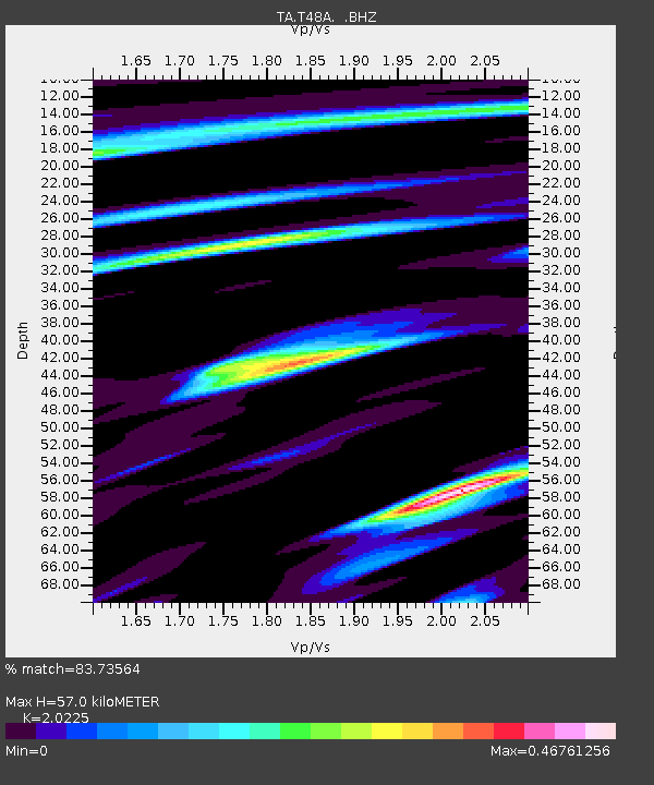
| Estimated Moho Depth: |
57.0 km |
| Estimated Crust Vp/Vs: |
2.02 |
| Assumed Crust Vp: |
6.444 km/s |
| Estimated Crust Vs: |
3.186 km/s |
| Estimated Crust Poisson's Ratio: |
0.34 |
|
| Radial Match: |
83.73564 % |
| Radial Bump: |
394 |
| Transverse Match: |
63.911606 % |
| Transverse Bump: |
400 |
| SOD ConfigId: |
512894 |
| Insert Time: |
2013-09-13 21:13:23.268 +0000 |
| GWidth: |
2.5 |
| Max Bumps: |
400 |
| Tol: |
0.001 |
|
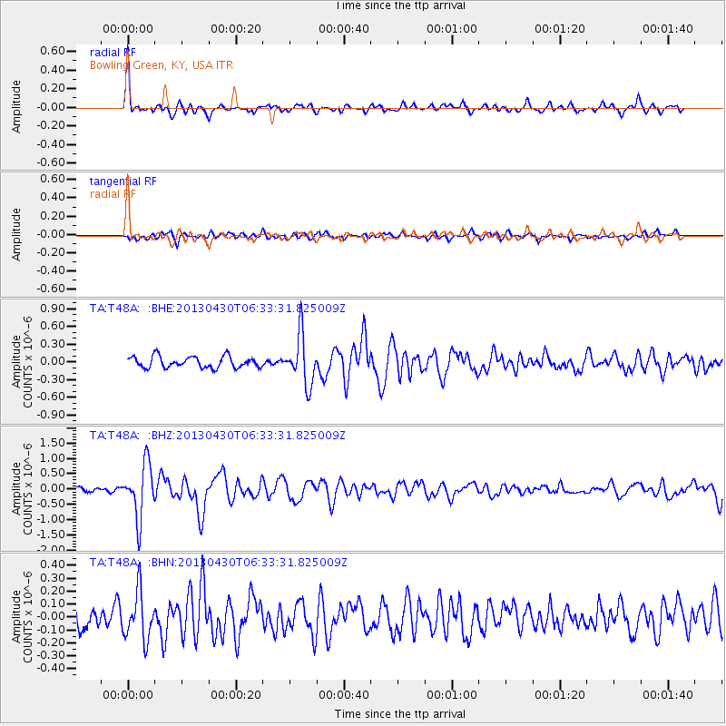
Signal To Noise
| Channel | StoN | STA | LTA |
| TA:T48A: :BHZ:20130430T06:33:31.825009Z | 6.5185013 | 8.800319E-7 | 1.3500525E-7 |
| TA:T48A: :BHN:20130430T06:33:31.825009Z | 2.0199883 | 1.8671452E-7 | 9.243347E-8 |
| TA:T48A: :BHE:20130430T06:33:31.825009Z | 4.483695 | 4.2497507E-7 | 9.478233E-8 |
| Arrivals |
| Ps | 9.5 SECOND |
| PpPs | 25 SECOND |
| PsPs/PpSs | 35 SECOND |


