You are here: Home > Network List > TA - USArray Transportable Network (new EarthScope stations) Stations List
> Station T53A Wise, VA, USA > Earthquake Result Viewer
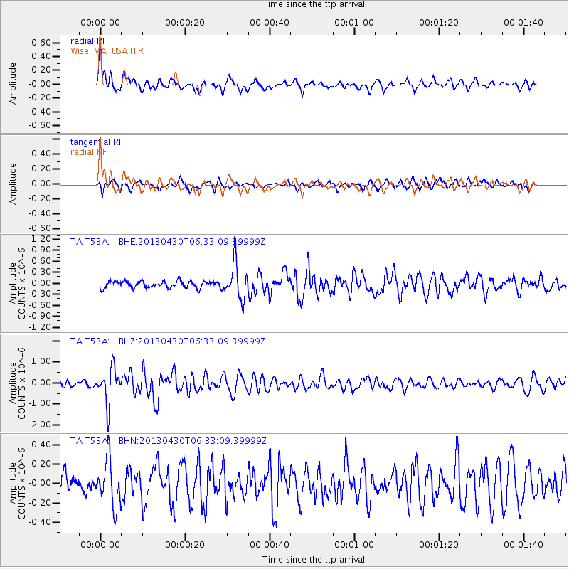
T53A Wise, VA, USA - Earthquake Result Viewer
*The percent match for this event was below the threshold and hence no stack was calculated.
| Earthquake location: |
Azores Islands Region |
| Earthquake latitude/longitude: |
37.6/-24.9 |
| Earthquake time(UTC): |
2013/04/30 (120) 06:25:23 GMT |
| Earthquake Depth: |
10 km |
| Earthquake Magnitude: |
5.8 MW, 5.9 MW, 5.9 MB |
| Earthquake Catalog/Contributor: |
NEIC PDE/NEIC PDE-W |
|
| Network: |
TA USArray Transportable Network (new EarthScope stations) |
| Station: |
T53A Wise, VA, USA |
| Lat/Lon: |
36.98 N/82.54 W |
| Elevation: |
818 m |
|
| Distance: |
45.2 deg |
| Az: |
287.661 deg |
| Baz: |
70.951 deg |
| Ray Param: |
$rayparam |
*The percent match for this event was below the threshold and hence was not used in the summary stack. |
|
| Radial Match: |
77.5721 % |
| Radial Bump: |
400 |
| Transverse Match: |
67.11429 % |
| Transverse Bump: |
390 |
| SOD ConfigId: |
512894 |
| Insert Time: |
2013-09-13 21:13:43.039 +0000 |
| GWidth: |
2.5 |
| Max Bumps: |
400 |
| Tol: |
0.001 |
|
Signal To Noise
| Channel | StoN | STA | LTA |
| TA:T53A: :BHZ:20130430T06:33:09.39999Z | 5.000308 | 8.2976516E-7 | 1.6594281E-7 |
| TA:T53A: :BHN:20130430T06:33:09.39999Z | 1.577249 | 2.4098614E-7 | 1.5278889E-7 |
| TA:T53A: :BHE:20130430T06:33:09.39999Z | 5.3291507 | 4.860902E-7 | 9.1213444E-8 |
| Arrivals |
| Ps | |
| PpPs | |
| PsPs/PpSs | |


