You are here: Home > Network List > TA - USArray Transportable Network (new EarthScope stations) Stations List
> Station T56A Rocky Mt, VA, USA > Earthquake Result Viewer
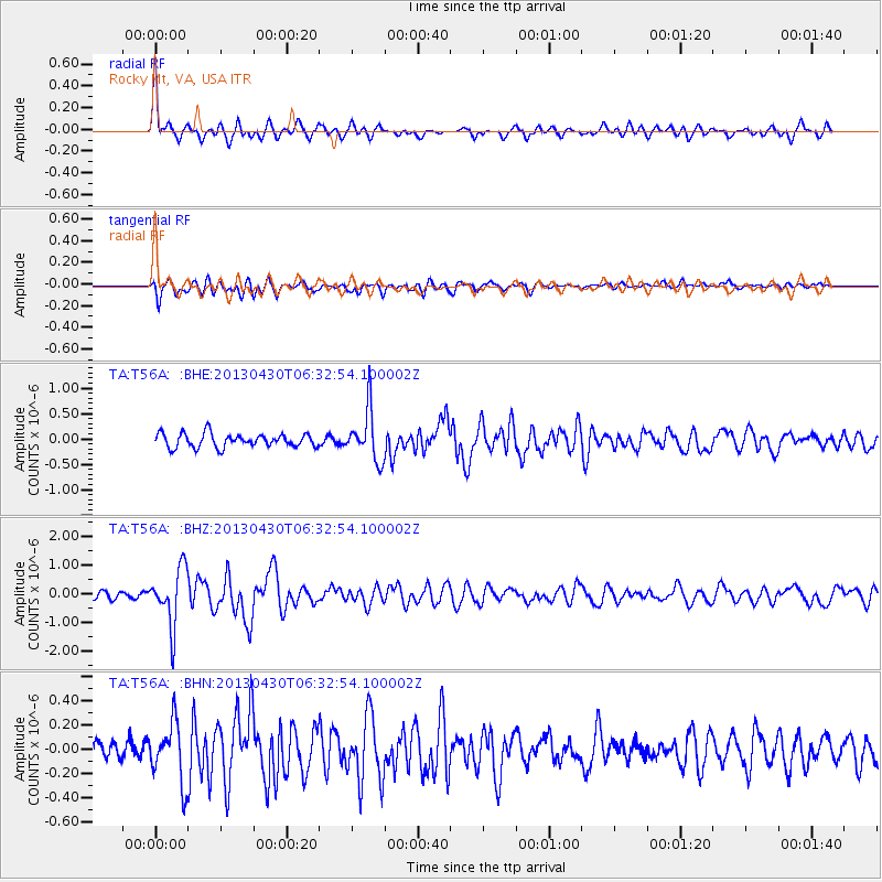
T56A Rocky Mt, VA, USA - Earthquake Result Viewer
*The percent match for this event was below the threshold and hence no stack was calculated.
| Earthquake location: |
Azores Islands Region |
| Earthquake latitude/longitude: |
37.6/-24.9 |
| Earthquake time(UTC): |
2013/04/30 (120) 06:25:23 GMT |
| Earthquake Depth: |
10 km |
| Earthquake Magnitude: |
5.8 MW, 5.9 MW, 5.9 MB |
| Earthquake Catalog/Contributor: |
NEIC PDE/NEIC PDE-W |
|
| Network: |
TA USArray Transportable Network (new EarthScope stations) |
| Station: |
T56A Rocky Mt, VA, USA |
| Lat/Lon: |
37.03 N/80.03 W |
| Elevation: |
387 m |
|
| Distance: |
43.3 deg |
| Az: |
286.808 deg |
| Baz: |
71.841 deg |
| Ray Param: |
$rayparam |
*The percent match for this event was below the threshold and hence was not used in the summary stack. |
|
| Radial Match: |
78.05342 % |
| Radial Bump: |
400 |
| Transverse Match: |
68.55741 % |
| Transverse Bump: |
400 |
| SOD ConfigId: |
512894 |
| Insert Time: |
2013-09-13 21:13:50.476 +0000 |
| GWidth: |
2.5 |
| Max Bumps: |
400 |
| Tol: |
0.001 |
|
Signal To Noise
| Channel | StoN | STA | LTA |
| TA:T56A: :BHZ:20130430T06:32:54.100002Z | 5.955279 | 9.922164E-7 | 1.6661124E-7 |
| TA:T56A: :BHN:20130430T06:32:54.100002Z | 1.8509766 | 2.4589752E-7 | 1.3284745E-7 |
| TA:T56A: :BHE:20130430T06:32:54.100002Z | 3.7604144 | 5.0353157E-7 | 1.339032E-7 |
| Arrivals |
| Ps | |
| PpPs | |
| PsPs/PpSs | |


