You are here: Home > Network List > TA - USArray Transportable Network (new EarthScope stations) Stations List
> Station O48A Farmland, IN, USA > Earthquake Result Viewer
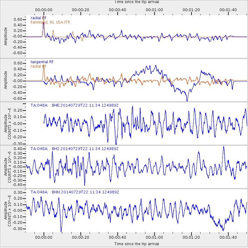
O48A Farmland, IN, USA - Earthquake Result Viewer
*The percent match for this event was below the threshold and hence no stack was calculated.
| Earthquake location: |
Northern Mid-Atlantic Ridge |
| Earthquake latitude/longitude: |
35.1/-36.3 |
| Earthquake time(UTC): |
2014/07/29 (210) 22:04:40 GMT |
| Earthquake Depth: |
0.0 km |
| Earthquake Magnitude: |
5.6 MW, 4.8 ms1mx, 4.9 Ms1, 4.8 MS, 4.5 mbtmp, 4.5 mb1mx, 4.6 mb1, 4.5 mb |
| Earthquake Catalog/Contributor: |
ISC/ISC |
|
| Network: |
TA USArray Transportable Network (new EarthScope stations) |
| Station: |
O48A Farmland, IN, USA |
| Lat/Lon: |
40.26 N/85.16 W |
| Elevation: |
300 m |
|
| Distance: |
38.6 deg |
| Az: |
292.544 deg |
| Baz: |
81.6 deg |
| Ray Param: |
$rayparam |
*The percent match for this event was below the threshold and hence was not used in the summary stack. |
|
| Radial Match: |
61.433205 % |
| Radial Bump: |
400 |
| Transverse Match: |
44.52798 % |
| Transverse Bump: |
400 |
| SOD ConfigId: |
3390531 |
| Insert Time: |
2019-04-13 02:28:41.607 +0000 |
| GWidth: |
2.5 |
| Max Bumps: |
400 |
| Tol: |
0.001 |
|
Signal To Noise
| Channel | StoN | STA | LTA |
| TA:O48A: :BHZ:20140729T22:11:34.124989Z | 1.5863891 | 1.364044E-7 | 8.5984205E-8 |
| TA:O48A: :BHN:20140729T22:11:34.124989Z | 0.9687432 | 2.1409444E-7 | 2.2100227E-7 |
| TA:O48A: :BHE:20140729T22:11:34.124989Z | 1.3771926 | 9.175124E-8 | 6.6621936E-8 |
| Arrivals |
| Ps | |
| PpPs | |
| PsPs/PpSs | |


