You are here: Home > Network List > TA - USArray Transportable Network (new EarthScope stations) Stations List
> Station U46A Springville, TN, USA > Earthquake Result Viewer
U46A Springville, TN, USA - Earthquake Result Viewer
| Earthquake location: |
Azores Islands Region |
| Earthquake latitude/longitude: |
37.6/-24.9 |
| Earthquake time(UTC): |
2013/04/30 (120) 06:25:23 GMT |
| Earthquake Depth: |
10 km |
| Earthquake Magnitude: |
5.8 MW, 5.9 MW, 5.9 MB |
| Earthquake Catalog/Contributor: |
NEIC PDE/NEIC PDE-W |
|
| Network: |
TA USArray Transportable Network (new EarthScope stations) |
| Station: |
U46A Springville, TN, USA |
| Lat/Lon: |
36.36 N/88.18 W |
| Elevation: |
146 m |
|
| Distance: |
49.7 deg |
| Az: |
289.003 deg |
| Baz: |
68.502 deg |
| Ray Param: |
0.06854503 |
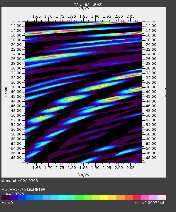
| Estimated Moho Depth: |
14.75 km |
| Estimated Crust Vp/Vs: |
2.08 |
| Assumed Crust Vp: |
6.444 km/s |
| Estimated Crust Vs: |
3.102 km/s |
| Estimated Crust Poisson's Ratio: |
0.35 |
|
| Radial Match: |
90.19303 % |
| Radial Bump: |
400 |
| Transverse Match: |
78.27362 % |
| Transverse Bump: |
400 |
| SOD ConfigId: |
512894 |
| Insert Time: |
2013-09-13 21:14:36.298 +0000 |
| GWidth: |
2.5 |
| Max Bumps: |
400 |
| Tol: |
0.001 |
|

Signal To Noise
| Channel | StoN | STA | LTA |
| TA:U46A: :BHZ:20130430T06:33:44.123989Z | 15.387056 | 1.4601252E-6 | 9.489308E-8 |
| TA:U46A: :BHN:20130430T06:33:44.123989Z | 4.1900077 | 5.6800457E-7 | 1.3556169E-7 |
| TA:U46A: :BHE:20130430T06:33:44.123989Z | 12.638163 | 1.5814392E-6 | 1.2513205E-7 |
| Arrivals |
| Ps | 2.6 SECOND |
| PpPs | 6.7 SECOND |
| PsPs/PpSs | 9.3 SECOND |


