You are here: Home > Network List > TA - USArray Transportable Network (new EarthScope stations) Stations List
> Station U44A Portageville, MO, USA > Earthquake Result Viewer
U44A Portageville, MO, USA - Earthquake Result Viewer
| Earthquake location: |
Azores Islands Region |
| Earthquake latitude/longitude: |
37.6/-24.9 |
| Earthquake time(UTC): |
2013/04/30 (120) 06:25:23 GMT |
| Earthquake Depth: |
10 km |
| Earthquake Magnitude: |
5.8 MW, 5.9 MW, 5.9 MB |
| Earthquake Catalog/Contributor: |
NEIC PDE/NEIC PDE-W |
|
| Network: |
TA USArray Transportable Network (new EarthScope stations) |
| Station: |
U44A Portageville, MO, USA |
| Lat/Lon: |
36.50 N/89.69 W |
| Elevation: |
89 m |
|
| Distance: |
50.8 deg |
| Az: |
289.764 deg |
| Baz: |
68.097 deg |
| Ray Param: |
0.067839906 |
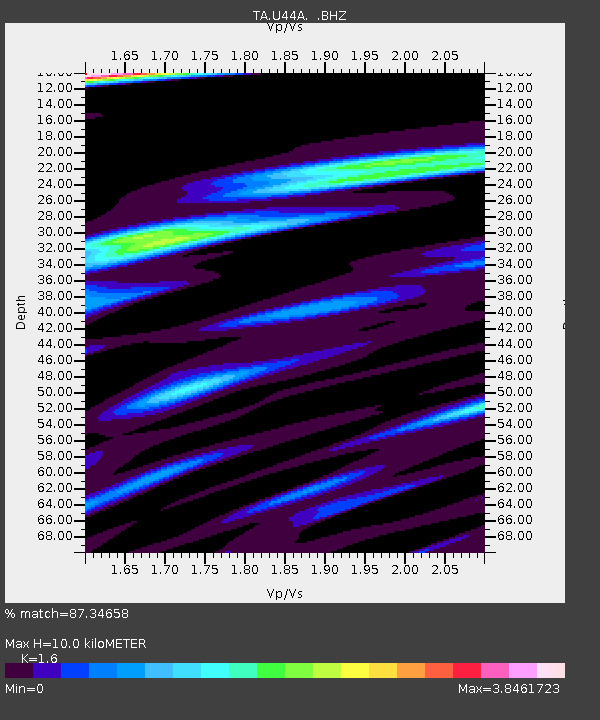
| Estimated Moho Depth: |
10.0 km |
| Estimated Crust Vp/Vs: |
1.60 |
| Assumed Crust Vp: |
6.444 km/s |
| Estimated Crust Vs: |
4.027 km/s |
| Estimated Crust Poisson's Ratio: |
0.18 |
|
| Radial Match: |
87.34658 % |
| Radial Bump: |
384 |
| Transverse Match: |
87.2821 % |
| Transverse Bump: |
400 |
| SOD ConfigId: |
512894 |
| Insert Time: |
2013-09-13 21:14:40.837 +0000 |
| GWidth: |
2.5 |
| Max Bumps: |
400 |
| Tol: |
0.001 |
|
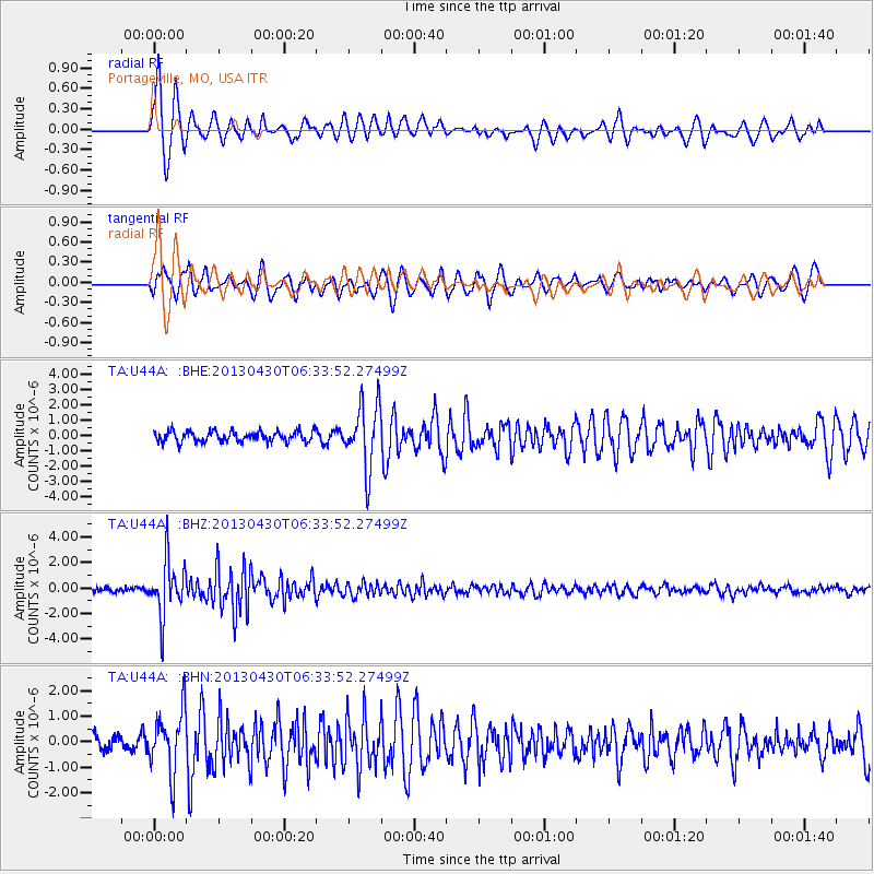
Signal To Noise
| Channel | StoN | STA | LTA |
| TA:U44A: :BHZ:20130430T06:33:52.27499Z | 14.593944 | 2.1388864E-6 | 1.4655987E-7 |
| TA:U44A: :BHN:20130430T06:33:52.27499Z | 3.6745965 | 1.223925E-6 | 3.330774E-7 |
| TA:U44A: :BHE:20130430T06:33:52.27499Z | 6.074814 | 2.0937368E-6 | 3.4465862E-7 |
| Arrivals |
| Ps | 1.0 SECOND |
| PpPs | 3.8 SECOND |
| PsPs/PpSs | 4.8 SECOND |


