You are here: Home > Network List > TA - USArray Transportable Network (new EarthScope stations) Stations List
> Station U60A Pendleton, NC, USA > Earthquake Result Viewer
U60A Pendleton, NC, USA - Earthquake Result Viewer
| Earthquake location: |
Azores Islands Region |
| Earthquake latitude/longitude: |
37.6/-24.9 |
| Earthquake time(UTC): |
2013/04/30 (120) 06:25:23 GMT |
| Earthquake Depth: |
10 km |
| Earthquake Magnitude: |
5.8 MW, 5.9 MW, 5.9 MB |
| Earthquake Catalog/Contributor: |
NEIC PDE/NEIC PDE-W |
|
| Network: |
TA USArray Transportable Network (new EarthScope stations) |
| Station: |
U60A Pendleton, NC, USA |
| Lat/Lon: |
36.47 N/77.16 W |
| Elevation: |
8.0 m |
|
| Distance: |
41.3 deg |
| Az: |
284.964 deg |
| Baz: |
72.187 deg |
| Ray Param: |
0.07389432 |
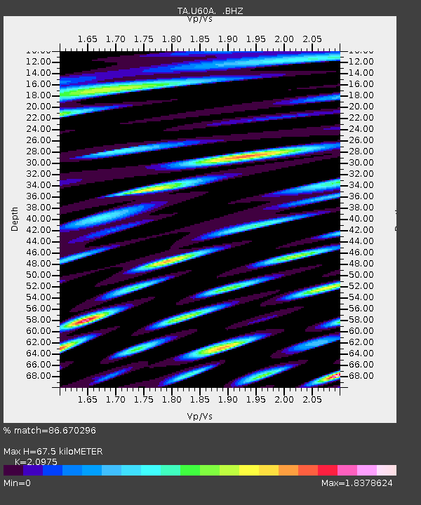
| Estimated Moho Depth: |
67.5 km |
| Estimated Crust Vp/Vs: |
2.10 |
| Assumed Crust Vp: |
6.565 km/s |
| Estimated Crust Vs: |
3.13 km/s |
| Estimated Crust Poisson's Ratio: |
0.35 |
|
| Radial Match: |
86.670296 % |
| Radial Bump: |
400 |
| Transverse Match: |
66.58225 % |
| Transverse Bump: |
400 |
| SOD ConfigId: |
512894 |
| Insert Time: |
2013-09-13 21:15:33.510 +0000 |
| GWidth: |
2.5 |
| Max Bumps: |
400 |
| Tol: |
0.001 |
|

Signal To Noise
| Channel | StoN | STA | LTA |
| TA:U60A: :BHZ:20130430T06:32:37.64999Z | 5.648153 | 1.1053969E-6 | 1.9570945E-7 |
| TA:U60A: :BHN:20130430T06:32:37.64999Z | 1.613175 | 3.8682936E-7 | 2.3979376E-7 |
| TA:U60A: :BHE:20130430T06:32:37.64999Z | 5.7130923 | 1.3052644E-6 | 2.2846898E-7 |
| Arrivals |
| Ps | 12 SECOND |
| PpPs | 30 SECOND |
| PsPs/PpSs | 42 SECOND |


