You are here: Home > Network List > TA - USArray Transportable Network (new EarthScope stations) Stations List
> Station V47A Nunnelly, TN, USA > Earthquake Result Viewer
V47A Nunnelly, TN, USA - Earthquake Result Viewer
| Earthquake location: |
Azores Islands Region |
| Earthquake latitude/longitude: |
37.6/-24.9 |
| Earthquake time(UTC): |
2013/04/30 (120) 06:25:23 GMT |
| Earthquake Depth: |
10 km |
| Earthquake Magnitude: |
5.8 MW, 5.9 MW, 5.9 MB |
| Earthquake Catalog/Contributor: |
NEIC PDE/NEIC PDE-W |
|
| Network: |
TA USArray Transportable Network (new EarthScope stations) |
| Station: |
V47A Nunnelly, TN, USA |
| Lat/Lon: |
35.83 N/87.52 W |
| Elevation: |
240 m |
|
| Distance: |
49.4 deg |
| Az: |
288.098 deg |
| Baz: |
68.3 deg |
| Ray Param: |
0.06873541 |
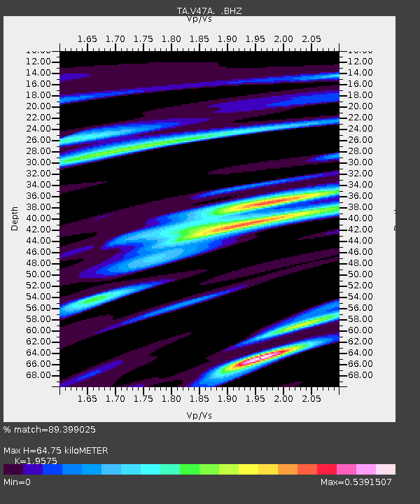
| Estimated Moho Depth: |
64.75 km |
| Estimated Crust Vp/Vs: |
1.96 |
| Assumed Crust Vp: |
6.476 km/s |
| Estimated Crust Vs: |
3.308 km/s |
| Estimated Crust Poisson's Ratio: |
0.32 |
|
| Radial Match: |
89.399025 % |
| Radial Bump: |
356 |
| Transverse Match: |
72.99555 % |
| Transverse Bump: |
400 |
| SOD ConfigId: |
512894 |
| Insert Time: |
2013-09-13 21:15:42.831 +0000 |
| GWidth: |
2.5 |
| Max Bumps: |
400 |
| Tol: |
0.001 |
|
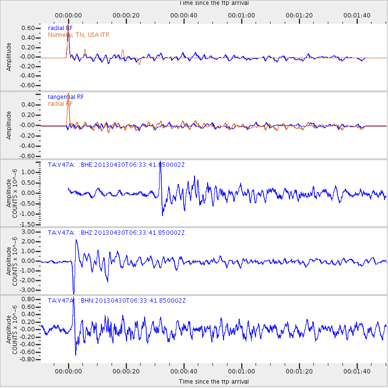
Signal To Noise
| Channel | StoN | STA | LTA |
| TA:V47A: :BHZ:20130430T06:33:41.850002Z | 13.7116785 | 1.2594808E-6 | 9.18546E-8 |
| TA:V47A: :BHN:20130430T06:33:41.850002Z | 4.6715946 | 3.1816927E-7 | 6.810721E-8 |
| TA:V47A: :BHE:20130430T06:33:41.850002Z | 6.4865074 | 5.712345E-7 | 8.806504E-8 |
| Arrivals |
| Ps | 10 SECOND |
| PpPs | 28 SECOND |
| PsPs/PpSs | 38 SECOND |


