You are here: Home > Network List > US - United States National Seismic Network Stations List
> Station AMTX Amarillo, Texas, USA > Earthquake Result Viewer
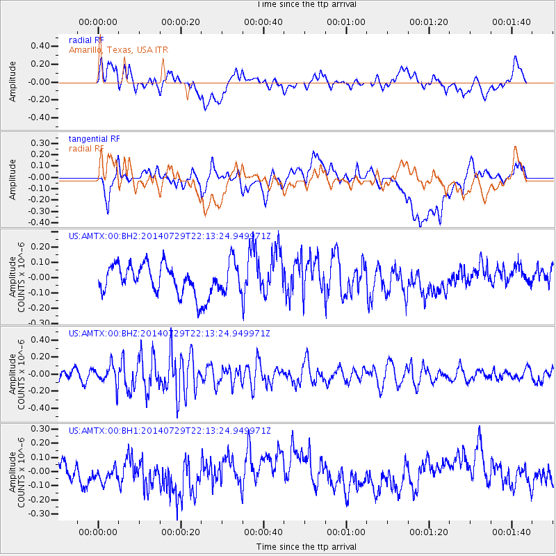
AMTX Amarillo, Texas, USA - Earthquake Result Viewer
*The percent match for this event was below the threshold and hence no stack was calculated.
| Earthquake location: |
Northern Mid-Atlantic Ridge |
| Earthquake latitude/longitude: |
35.1/-36.3 |
| Earthquake time(UTC): |
2014/07/29 (210) 22:04:40 GMT |
| Earthquake Depth: |
0.0 km |
| Earthquake Magnitude: |
5.6 MW, 4.8 ms1mx, 4.9 Ms1, 4.8 MS, 4.5 mbtmp, 4.5 mb1mx, 4.6 mb1, 4.5 mb |
| Earthquake Catalog/Contributor: |
ISC/ISC |
|
| Network: |
US United States National Seismic Network |
| Station: |
AMTX Amarillo, Texas, USA |
| Lat/Lon: |
34.53 N/101.41 W |
| Elevation: |
1010 m |
|
| Distance: |
52.6 deg |
| Az: |
289.383 deg |
| Baz: |
69.488 deg |
| Ray Param: |
$rayparam |
*The percent match for this event was below the threshold and hence was not used in the summary stack. |
|
| Radial Match: |
42.201283 % |
| Radial Bump: |
400 |
| Transverse Match: |
43.534767 % |
| Transverse Bump: |
400 |
| SOD ConfigId: |
3390531 |
| Insert Time: |
2019-04-13 02:29:32.105 +0000 |
| GWidth: |
2.5 |
| Max Bumps: |
400 |
| Tol: |
0.001 |
|
Signal To Noise
| Channel | StoN | STA | LTA |
| US:AMTX:00:BHZ:20140729T22:13:24.949971Z | 1.7970626 | 1.2079089E-7 | 6.721573E-8 |
| US:AMTX:00:BH1:20140729T22:13:24.949971Z | 1.2212381 | 7.306527E-8 | 5.982886E-8 |
| US:AMTX:00:BH2:20140729T22:13:24.949971Z | 1.1918128 | 1.01184156E-7 | 8.4899376E-8 |
| Arrivals |
| Ps | |
| PpPs | |
| PsPs/PpSs | |


