You are here: Home > Network List > TA - USArray Transportable Network (new EarthScope stations) Stations List
> Station W50A Signal Mountain, TN, USA > Earthquake Result Viewer
W50A Signal Mountain, TN, USA - Earthquake Result Viewer

| Earthquake location: |
Azores Islands Region |
| Earthquake latitude/longitude: |
37.6/-24.9 |
| Earthquake time(UTC): |
2013/04/30 (120) 06:25:23 GMT |
| Earthquake Depth: |
10 km |
| Earthquake Magnitude: |
5.8 MW, 5.9 MW, 5.9 MB |
| Earthquake Catalog/Contributor: |
NEIC PDE/NEIC PDE-W |
|
| Network: |
TA USArray Transportable Network (new EarthScope stations) |
| Station: |
W50A Signal Mountain, TN, USA |
| Lat/Lon: |
35.20 N/85.31 W |
| Elevation: |
587 m |
|
| Distance: |
47.9 deg |
| Az: |
286.439 deg |
| Baz: |
68.482 deg |
| Ray Param: |
0.06967456 |
| Estimated Moho Depth: |
47.25 km |
| Estimated Crust Vp/Vs: |
1.75 |
| Assumed Crust Vp: |
6.35 km/s |
| Estimated Crust Vs: |
3.629 km/s |
| Estimated Crust Poisson's Ratio: |
0.26 |
|
| Radial Match: |
80.601616 % |
| Radial Bump: |
388 |
| Transverse Match: |
63.877075 % |
| Transverse Bump: |
400 |
| SOD ConfigId: |
512894 |
| Insert Time: |
2013-09-13 21:16:53.516 +0000 |
| GWidth: |
2.5 |
| Max Bumps: |
400 |
| Tol: |
0.001 |
|
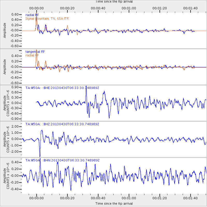
Signal To Noise
| Channel | StoN | STA | LTA |
| TA:W50A: :BHZ:20130430T06:33:30.748989Z | 7.6605735 | 1.014795E-6 | 1.3246985E-7 |
| TA:W50A: :BHN:20130430T06:33:30.748989Z | 1.9647232 | 1.9921745E-7 | 1.0139721E-7 |
| TA:W50A: :BHE:20130430T06:33:30.748989Z | 4.519589 | 3.885795E-7 | 8.5976744E-8 |
| Arrivals |
| Ps | 5.9 SECOND |
| PpPs | 19 SECOND |
| PsPs/PpSs | 25 SECOND |


