You are here: Home > Network List > TA - USArray Transportable Network (new EarthScope stations) Stations List
> Station W61A Ground Anchor Farm, New Bern, NC, USA > Earthquake Result Viewer
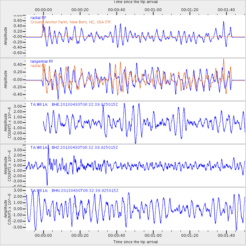
W61A Ground Anchor Farm, New Bern, NC, USA - Earthquake Result Viewer
*The percent match for this event was below the threshold and hence no stack was calculated.
| Earthquake location: |
Azores Islands Region |
| Earthquake latitude/longitude: |
37.6/-24.9 |
| Earthquake time(UTC): |
2013/04/30 (120) 06:25:23 GMT |
| Earthquake Depth: |
10 km |
| Earthquake Magnitude: |
5.8 MW, 5.9 MW, 5.9 MB |
| Earthquake Catalog/Contributor: |
NEIC PDE/NEIC PDE-W |
|
| Network: |
TA USArray Transportable Network (new EarthScope stations) |
| Station: |
W61A Ground Anchor Farm, New Bern, NC, USA |
| Lat/Lon: |
35.18 N/76.99 W |
| Elevation: |
6.0 m |
|
| Distance: |
41.6 deg |
| Az: |
283.046 deg |
| Baz: |
70.847 deg |
| Ray Param: |
$rayparam |
*The percent match for this event was below the threshold and hence was not used in the summary stack. |
|
| Radial Match: |
50.76987 % |
| Radial Bump: |
400 |
| Transverse Match: |
55.018642 % |
| Transverse Bump: |
375 |
| SOD ConfigId: |
512894 |
| Insert Time: |
2013-09-13 21:17:26.013 +0000 |
| GWidth: |
2.5 |
| Max Bumps: |
400 |
| Tol: |
0.001 |
|
Signal To Noise
| Channel | StoN | STA | LTA |
| TA:W61A: :BHZ:20130430T06:32:39.925015Z | 3.4354963 | 1.4791394E-6 | 4.305461E-7 |
| TA:W61A: :BHN:20130430T06:32:39.925015Z | 0.9640678 | 1.0393984E-6 | 1.0781382E-6 |
| TA:W61A: :BHE:20130430T06:32:39.925015Z | 1.4884168 | 1.475423E-6 | 9.912701E-7 |
| Arrivals |
| Ps | |
| PpPs | |
| PsPs/PpSs | |


