You are here: Home > Network List > TA - USArray Transportable Network (new EarthScope stations) Stations List
> Station X47A Russelville, AR, USA > Earthquake Result Viewer
X47A Russelville, AR, USA - Earthquake Result Viewer
| Earthquake location: |
Azores Islands Region |
| Earthquake latitude/longitude: |
37.6/-24.9 |
| Earthquake time(UTC): |
2013/04/30 (120) 06:25:23 GMT |
| Earthquake Depth: |
10 km |
| Earthquake Magnitude: |
5.8 MW, 5.9 MW, 5.9 MB |
| Earthquake Catalog/Contributor: |
NEIC PDE/NEIC PDE-W |
|
| Network: |
TA USArray Transportable Network (new EarthScope stations) |
| Station: |
X47A Russelville, AR, USA |
| Lat/Lon: |
34.52 N/87.86 W |
| Elevation: |
212 m |
|
| Distance: |
50.1 deg |
| Az: |
286.65 deg |
| Baz: |
67.172 deg |
| Ray Param: |
0.06825835 |
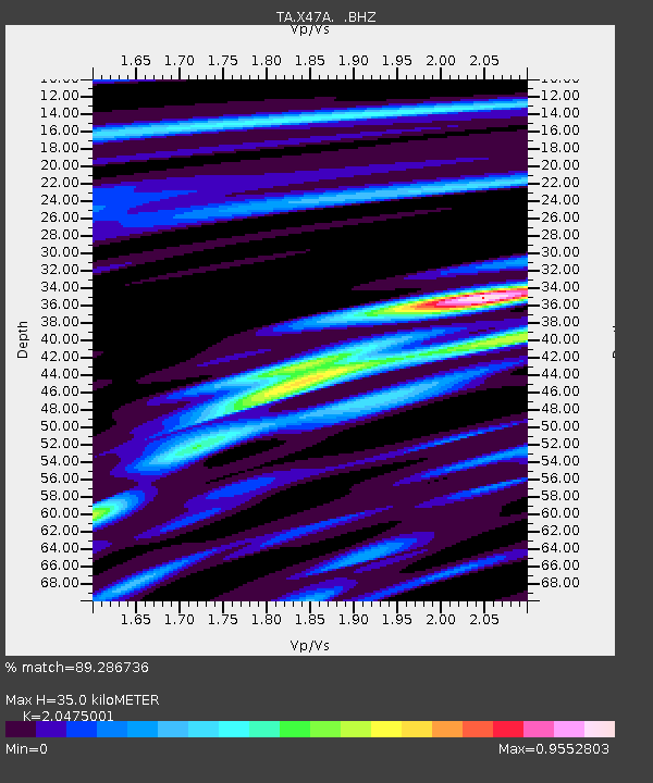
| Estimated Moho Depth: |
35.0 km |
| Estimated Crust Vp/Vs: |
2.05 |
| Assumed Crust Vp: |
6.476 km/s |
| Estimated Crust Vs: |
3.163 km/s |
| Estimated Crust Poisson's Ratio: |
0.34 |
|
| Radial Match: |
89.286736 % |
| Radial Bump: |
326 |
| Transverse Match: |
76.74742 % |
| Transverse Bump: |
400 |
| SOD ConfigId: |
512894 |
| Insert Time: |
2013-09-13 21:17:40.958 +0000 |
| GWidth: |
2.5 |
| Max Bumps: |
400 |
| Tol: |
0.001 |
|

Signal To Noise
| Channel | StoN | STA | LTA |
| TA:X47A: :BHZ:20130430T06:33:47.550015Z | 14.372169 | 1.3021124E-6 | 9.059958E-8 |
| TA:X47A: :BHN:20130430T06:33:47.550015Z | 4.087953 | 3.559413E-7 | 8.707079E-8 |
| TA:X47A: :BHE:20130430T06:33:47.550015Z | 7.5762925 | 6.719092E-7 | 8.868575E-8 |
| Arrivals |
| Ps | 6.0 SECOND |
| PpPs | 16 SECOND |
| PsPs/PpSs | 22 SECOND |


