You are here: Home > Network List > TA - USArray Transportable Network (new EarthScope stations) Stations List
> Station X50B Fort Payne, AL, USA > Earthquake Result Viewer
X50B Fort Payne, AL, USA - Earthquake Result Viewer
| Earthquake location: |
Azores Islands Region |
| Earthquake latitude/longitude: |
37.6/-24.9 |
| Earthquake time(UTC): |
2013/04/30 (120) 06:25:23 GMT |
| Earthquake Depth: |
10 km |
| Earthquake Magnitude: |
5.8 MW, 5.9 MW, 5.9 MB |
| Earthquake Catalog/Contributor: |
NEIC PDE/NEIC PDE-W |
|
| Network: |
TA USArray Transportable Network (new EarthScope stations) |
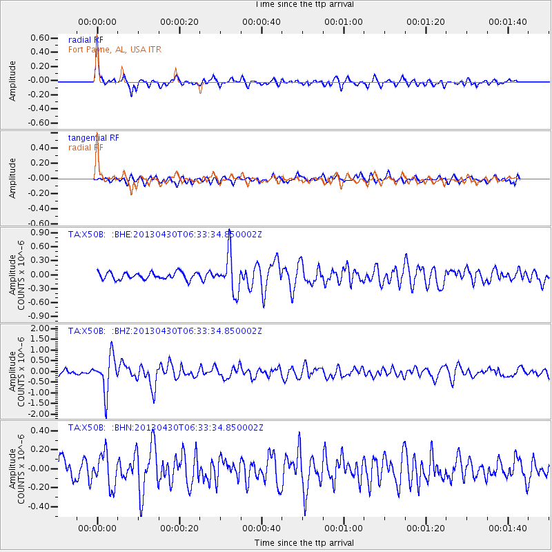
| Station: |
X50B Fort Payne, AL, USA |
| Lat/Lon: |
34.46 N/85.65 W |
| Elevation: |
494 m |
|
| Distance: |
48.5 deg |
| Az: |
285.66 deg |
| Baz: |
67.77 deg |
| Ray Param: |
0.06934026 |
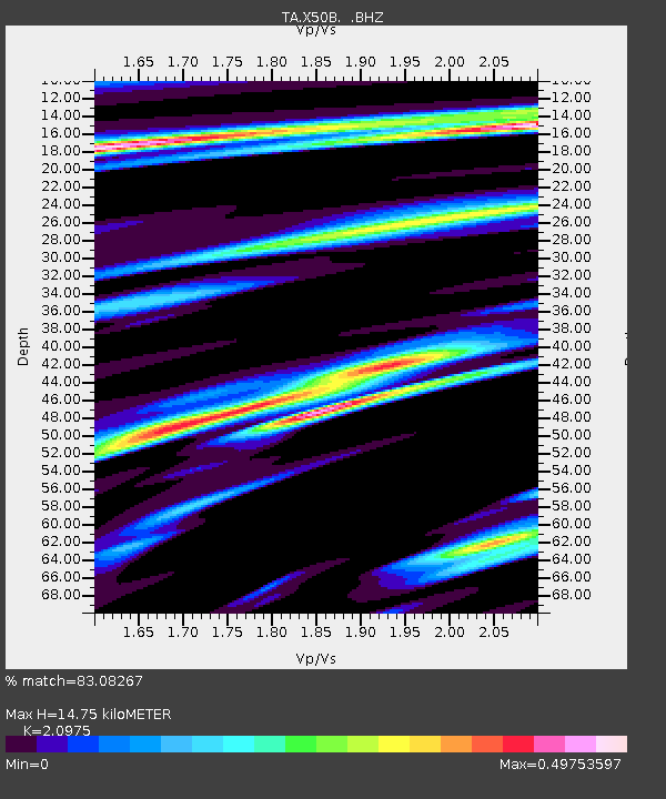
| Estimated Moho Depth: |
14.75 km |
| Estimated Crust Vp/Vs: |
2.10 |
| Assumed Crust Vp: |
6.35 km/s |
| Estimated Crust Vs: |
3.027 km/s |
| Estimated Crust Poisson's Ratio: |
0.35 |
|
| Radial Match: |
83.08267 % |
| Radial Bump: |
372 |
| Transverse Match: |
59.76536 % |
| Transverse Bump: |
400 |
| SOD ConfigId: |
512894 |
| Insert Time: |
2013-09-13 21:17:51.834 +0000 |
| GWidth: |
2.5 |
| Max Bumps: |
400 |
| Tol: |
0.001 |
|
Signal To Noise
| Channel | StoN | STA | LTA |
| TA:X50B: :BHZ:20130430T06:33:34.850002Z | 8.106479 | 8.596E-7 | 1.06038634E-7 |
| TA:X50B: :BHN:20130430T06:33:34.850002Z | 2.0568411 | 1.7639627E-7 | 8.576076E-8 |
| TA:X50B: :BHE:20130430T06:33:34.850002Z | 5.459457 | 4.1207062E-7 | 7.547832E-8 |
| Arrivals |
| Ps | 2.7 SECOND |
| PpPs | 6.8 SECOND |
| PsPs/PpSs | 9.5 SECOND |


