You are here: Home > Network List > TA - USArray Transportable Network (new EarthScope stations) Stations List
> Station X57A Johnson Farm, Hartsville, SC, USA > Earthquake Result Viewer
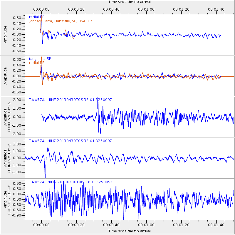
X57A Johnson Farm, Hartsville, SC, USA - Earthquake Result Viewer
*The percent match for this event was below the threshold and hence no stack was calculated.
| Earthquake location: |
Azores Islands Region |
| Earthquake latitude/longitude: |
37.6/-24.9 |
| Earthquake time(UTC): |
2013/04/30 (120) 06:25:23 GMT |
| Earthquake Depth: |
10 km |
| Earthquake Magnitude: |
5.8 MW, 5.9 MW, 5.9 MB |
| Earthquake Catalog/Contributor: |
NEIC PDE/NEIC PDE-W |
|
| Network: |
TA USArray Transportable Network (new EarthScope stations) |
| Station: |
X57A Johnson Farm, Hartsville, SC, USA |
| Lat/Lon: |
34.46 N/80.09 W |
| Elevation: |
133 m |
|
| Distance: |
44.2 deg |
| Az: |
283.343 deg |
| Baz: |
69.3 deg |
| Ray Param: |
$rayparam |
*The percent match for this event was below the threshold and hence was not used in the summary stack. |
|
| Radial Match: |
71.584015 % |
| Radial Bump: |
400 |
| Transverse Match: |
67.976395 % |
| Transverse Bump: |
400 |
| SOD ConfigId: |
512894 |
| Insert Time: |
2013-09-13 21:18:10.052 +0000 |
| GWidth: |
2.5 |
| Max Bumps: |
400 |
| Tol: |
0.001 |
|
Signal To Noise
| Channel | StoN | STA | LTA |
| TA:X57A: :BHZ:20130430T06:33:01.325009Z | 6.2350335 | 1.0119658E-6 | 1.6230318E-7 |
| TA:X57A: :BHN:20130430T06:33:01.325009Z | 2.4865336 | 3.3886263E-7 | 1.3627913E-7 |
| TA:X57A: :BHE:20130430T06:33:01.325009Z | 5.38958 | 9.3898325E-7 | 1.7422198E-7 |
| Arrivals |
| Ps | |
| PpPs | |
| PsPs/PpSs | |


