You are here: Home > Network List > TA - USArray Transportable Network (new EarthScope stations) Stations List
> Station Y51A Rockmart, GA, USA > Earthquake Result Viewer
Y51A Rockmart, GA, USA - Earthquake Result Viewer
| Earthquake location: |
Azores Islands Region |
| Earthquake latitude/longitude: |
37.6/-24.9 |
| Earthquake time(UTC): |
2013/04/30 (120) 06:25:23 GMT |
| Earthquake Depth: |
10 km |
| Earthquake Magnitude: |
5.8 MW, 5.9 MW, 5.9 MB |
| Earthquake Catalog/Contributor: |
NEIC PDE/NEIC PDE-W |
|
| Network: |
TA USArray Transportable Network (new EarthScope stations) |
| Station: |
Y51A Rockmart, GA, USA |
| Lat/Lon: |
33.90 N/85.06 W |
| Elevation: |
380 m |
|
| Distance: |
48.2 deg |
| Az: |
284.719 deg |
| Baz: |
67.473 deg |
| Ray Param: |
0.06948983 |
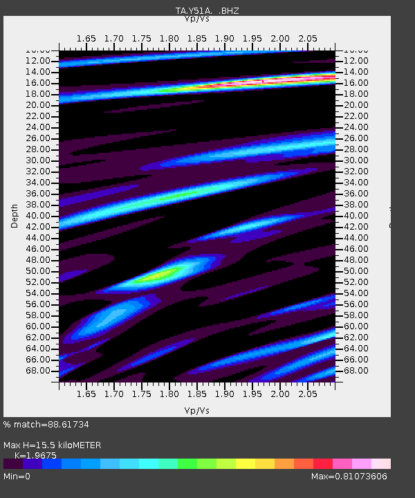
| Estimated Moho Depth: |
15.5 km |
| Estimated Crust Vp/Vs: |
1.97 |
| Assumed Crust Vp: |
6.719 km/s |
| Estimated Crust Vs: |
3.415 km/s |
| Estimated Crust Poisson's Ratio: |
0.33 |
|
| Radial Match: |
88.61734 % |
| Radial Bump: |
370 |
| Transverse Match: |
70.321266 % |
| Transverse Bump: |
400 |
| SOD ConfigId: |
512894 |
| Insert Time: |
2013-09-13 21:18:38.388 +0000 |
| GWidth: |
2.5 |
| Max Bumps: |
400 |
| Tol: |
0.001 |
|
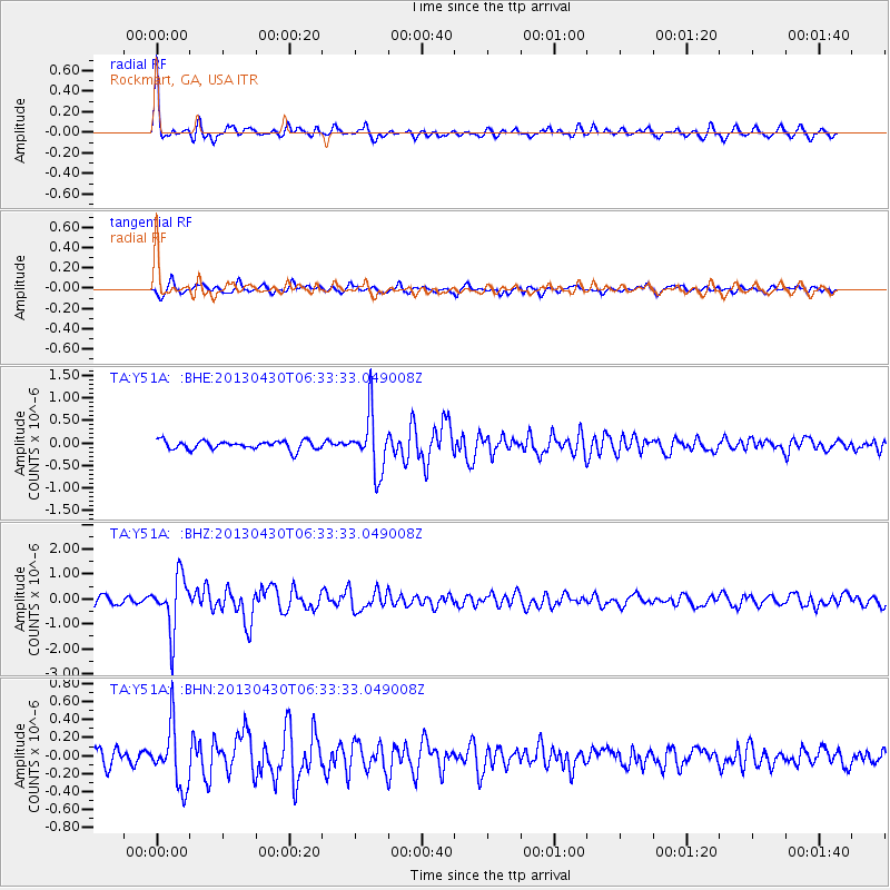
Signal To Noise
| Channel | StoN | STA | LTA |
| TA:Y51A: :BHZ:20130430T06:33:33.049008Z | 8.198297 | 1.0849385E-6 | 1.3233706E-7 |
| TA:Y51A: :BHN:20130430T06:33:33.049008Z | 3.9023595 | 3.4011174E-7 | 8.7155414E-8 |
| TA:Y51A: :BHE:20130430T06:33:33.049008Z | 6.5853324 | 6.3293214E-7 | 9.61124E-8 |
| Arrivals |
| Ps | 2.4 SECOND |
| PpPs | 6.4 SECOND |
| PsPs/PpSs | 8.8 SECOND |


