You are here: Home > Network List > TA - USArray Transportable Network (new EarthScope stations) Stations List
> Station Z51A Franklin, GA, USA > Earthquake Result Viewer
Z51A Franklin, GA, USA - Earthquake Result Viewer
| Earthquake location: |
Azores Islands Region |
| Earthquake latitude/longitude: |
37.6/-24.9 |
| Earthquake time(UTC): |
2013/04/30 (120) 06:25:23 GMT |
| Earthquake Depth: |
10 km |
| Earthquake Magnitude: |
5.8 MW, 5.9 MW, 5.9 MB |
| Earthquake Catalog/Contributor: |
NEIC PDE/NEIC PDE-W |
|
| Network: |
TA USArray Transportable Network (new EarthScope stations) |
| Station: |
Z51A Franklin, GA, USA |
| Lat/Lon: |
33.32 N/85.17 W |
| Elevation: |
249 m |
|
| Distance: |
48.5 deg |
| Az: |
284.05 deg |
| Baz: |
66.968 deg |
| Ray Param: |
0.069290504 |
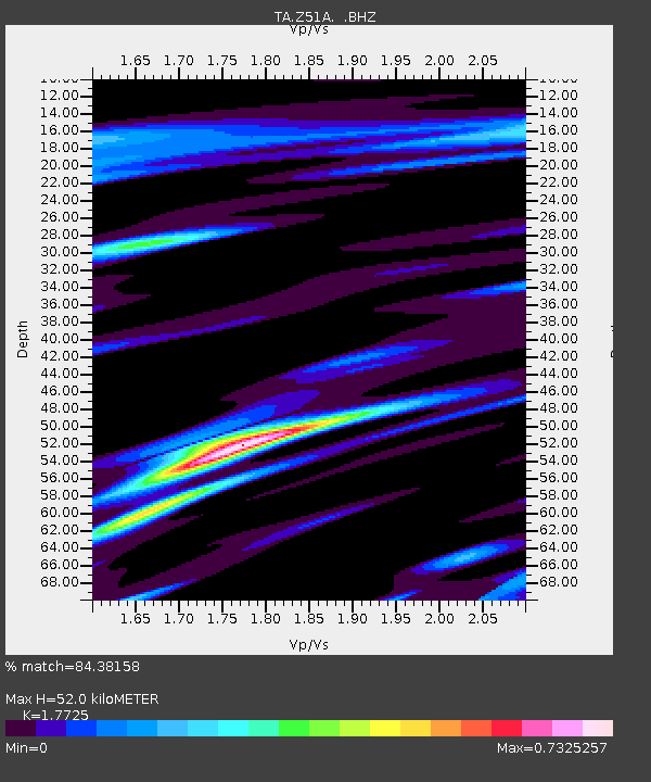
| Estimated Moho Depth: |
52.0 km |
| Estimated Crust Vp/Vs: |
1.77 |
| Assumed Crust Vp: |
6.719 km/s |
| Estimated Crust Vs: |
3.791 km/s |
| Estimated Crust Poisson's Ratio: |
0.27 |
|
| Radial Match: |
84.38158 % |
| Radial Bump: |
393 |
| Transverse Match: |
62.82162 % |
| Transverse Bump: |
400 |
| SOD ConfigId: |
512894 |
| Insert Time: |
2013-09-13 21:19:17.788 +0000 |
| GWidth: |
2.5 |
| Max Bumps: |
400 |
| Tol: |
0.001 |
|

Signal To Noise
| Channel | StoN | STA | LTA |
| TA:Z51A: :BHZ:20130430T06:33:35.424008Z | 6.536069 | 1.0034781E-6 | 1.5352931E-7 |
| TA:Z51A: :BHN:20130430T06:33:35.424008Z | 3.2990735 | 2.9036988E-7 | 8.801558E-8 |
| TA:Z51A: :BHE:20130430T06:33:35.424008Z | 5.386829 | 6.606015E-7 | 1.2263271E-7 |
| Arrivals |
| Ps | 6.4 SECOND |
| PpPs | 20 SECOND |
| PsPs/PpSs | 26 SECOND |


