You are here: Home > Network List > US - United States National Seismic Network Stations List
> Station AMTX Amarillo, Texas, USA > Earthquake Result Viewer
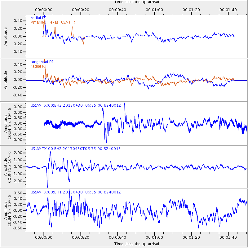
AMTX Amarillo, Texas, USA - Earthquake Result Viewer
*The percent match for this event was below the threshold and hence no stack was calculated.
| Earthquake location: |
Azores Islands Region |
| Earthquake latitude/longitude: |
37.6/-24.9 |
| Earthquake time(UTC): |
2013/04/30 (120) 06:25:23 GMT |
| Earthquake Depth: |
10 km |
| Earthquake Magnitude: |
5.8 MW, 5.9 MW, 5.9 MB |
| Earthquake Catalog/Contributor: |
NEIC PDE/NEIC PDE-W |
|
| Network: |
US United States National Seismic Network |
| Station: |
AMTX Amarillo, Texas, USA |
| Lat/Lon: |
34.53 N/101.41 W |
| Elevation: |
1010 m |
|
| Distance: |
60.3 deg |
| Az: |
292.414 deg |
| Baz: |
62.806 deg |
| Ray Param: |
$rayparam |
*The percent match for this event was below the threshold and hence was not used in the summary stack. |
|
| Radial Match: |
56.77002 % |
| Radial Bump: |
400 |
| Transverse Match: |
34.77163 % |
| Transverse Bump: |
400 |
| SOD ConfigId: |
512894 |
| Insert Time: |
2013-09-13 21:20:14.500 +0000 |
| GWidth: |
2.5 |
| Max Bumps: |
400 |
| Tol: |
0.001 |
|
Signal To Noise
| Channel | StoN | STA | LTA |
| US:AMTX:00:BHZ:20130430T06:35:00.824001Z | 11.826965 | 1.1377705E-6 | 9.62014E-8 |
| US:AMTX:00:BH1:20130430T06:35:00.824001Z | 1.286501 | 3.4708992E-7 | 2.6979373E-7 |
| US:AMTX:00:BH2:20130430T06:35:00.824001Z | 4.2773438 | 4.5527463E-7 | 1.0643864E-7 |
| Arrivals |
| Ps | |
| PpPs | |
| PsPs/PpSs | |


