You are here: Home > Network List > US - United States National Seismic Network Stations List
> Station MNTX Cornudas Mountains, Texas, USA > Earthquake Result Viewer
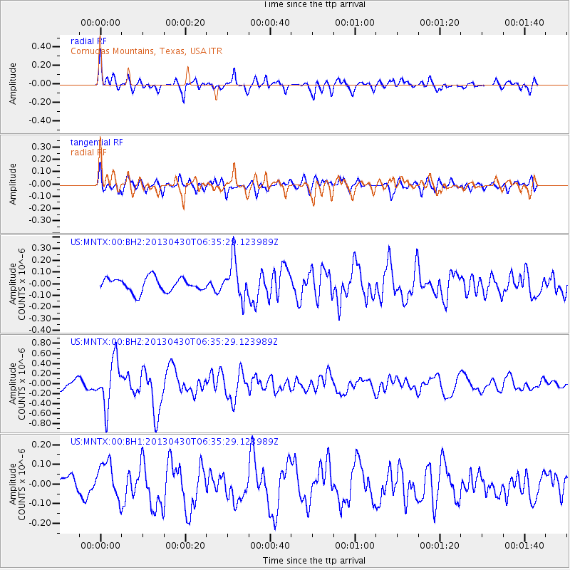
MNTX Cornudas Mountains, Texas, USA - Earthquake Result Viewer
*The percent match for this event was below the threshold and hence no stack was calculated.
| Earthquake location: |
Azores Islands Region |
| Earthquake latitude/longitude: |
37.6/-24.9 |
| Earthquake time(UTC): |
2013/04/30 (120) 06:25:23 GMT |
| Earthquake Depth: |
10 km |
| Earthquake Magnitude: |
5.8 MW, 5.9 MW, 5.9 MB |
| Earthquake Catalog/Contributor: |
NEIC PDE/NEIC PDE-W |
|
| Network: |
US United States National Seismic Network |
| Station: |
MNTX Cornudas Mountains, Texas, USA |
| Lat/Lon: |
31.70 N/105.38 W |
| Elevation: |
404 m |
|
| Distance: |
64.5 deg |
| Az: |
291.411 deg |
| Baz: |
60.179 deg |
| Ray Param: |
$rayparam |
*The percent match for this event was below the threshold and hence was not used in the summary stack. |
|
| Radial Match: |
72.72719 % |
| Radial Bump: |
400 |
| Transverse Match: |
49.59781 % |
| Transverse Bump: |
400 |
| SOD ConfigId: |
512894 |
| Insert Time: |
2013-09-13 21:21:50.363 +0000 |
| GWidth: |
2.5 |
| Max Bumps: |
400 |
| Tol: |
0.001 |
|
Signal To Noise
| Channel | StoN | STA | LTA |
| US:MNTX:00:BHZ:20130430T06:35:29.123989Z | 5.710906 | 4.741542E-7 | 8.3026094E-8 |
| US:MNTX:00:BH1:20130430T06:35:29.123989Z | 1.2705423 | 9.6884364E-8 | 7.625434E-8 |
| US:MNTX:00:BH2:20130430T06:35:29.123989Z | 2.8397088 | 1.6725657E-7 | 5.88992E-8 |
| Arrivals |
| Ps | |
| PpPs | |
| PsPs/PpSs | |


