You are here: Home > Network List > UW - Pacific Northwest Regional Seismic Network Stations List
> Station LEBA Lebam, WA, USA > Earthquake Result Viewer
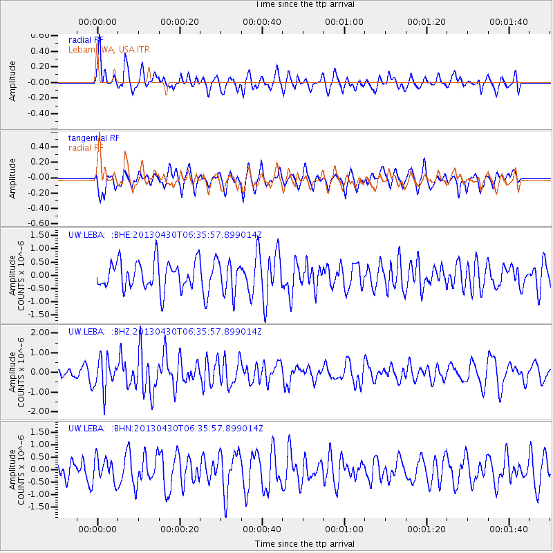
LEBA Lebam, WA, USA - Earthquake Result Viewer
*The percent match for this event was below the threshold and hence no stack was calculated.
| Earthquake location: |
Azores Islands Region |
| Earthquake latitude/longitude: |
37.6/-24.9 |
| Earthquake time(UTC): |
2013/04/30 (120) 06:25:23 GMT |
| Earthquake Depth: |
10 km |
| Earthquake Magnitude: |
5.8 MW, 5.9 MW, 5.9 MB |
| Earthquake Catalog/Contributor: |
NEIC PDE/NEIC PDE-W |
|
| Network: |
UW Pacific Northwest Regional Seismic Network |
| Station: |
LEBA Lebam, WA, USA |
| Lat/Lon: |
46.55 N/123.56 W |
| Elevation: |
73 m |
|
| Distance: |
69.1 deg |
| Az: |
313.07 deg |
| Baz: |
57.219 deg |
| Ray Param: |
$rayparam |
*The percent match for this event was below the threshold and hence was not used in the summary stack. |
|
| Radial Match: |
59.912605 % |
| Radial Bump: |
400 |
| Transverse Match: |
43.416885 % |
| Transverse Bump: |
400 |
| SOD ConfigId: |
512894 |
| Insert Time: |
2013-09-13 21:24:37.253 +0000 |
| GWidth: |
2.5 |
| Max Bumps: |
400 |
| Tol: |
0.001 |
|
Signal To Noise
| Channel | StoN | STA | LTA |
| UW:LEBA: :BHZ:20130430T06:35:57.899014Z | 3.8017247 | 7.68569E-7 | 2.0216325E-7 |
| UW:LEBA: :BHN:20130430T06:35:57.899014Z | 1.3614882 | 4.669519E-7 | 3.4297167E-7 |
| UW:LEBA: :BHE:20130430T06:35:57.899014Z | 1.1529531 | 5.962565E-7 | 5.1715585E-7 |
| Arrivals |
| Ps | |
| PpPs | |
| PsPs/PpSs | |


