You are here: Home > Network List > UW - Pacific Northwest Regional Seismic Network Stations List
> Station MRBL Marblemount, WA, USA > Earthquake Result Viewer
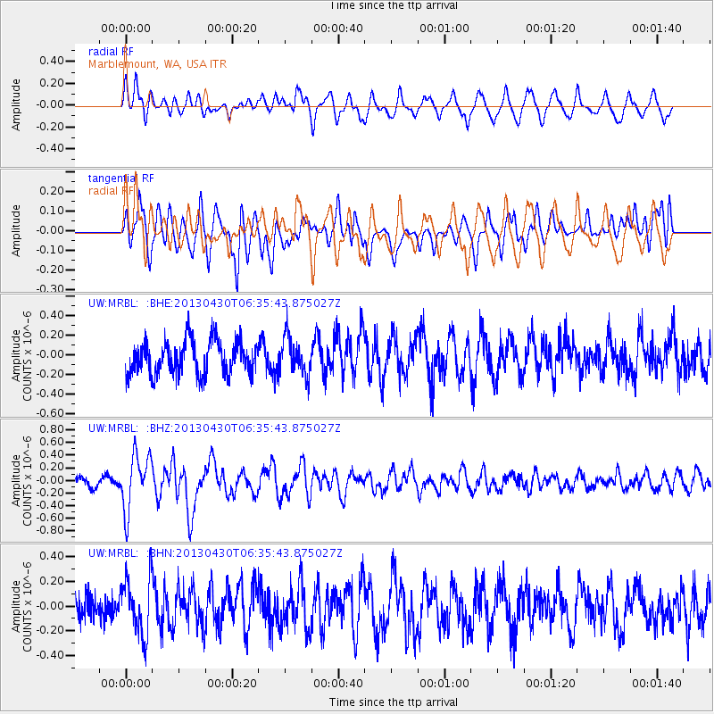
MRBL Marblemount, WA, USA - Earthquake Result Viewer
*The percent match for this event was below the threshold and hence no stack was calculated.
| Earthquake location: |
Azores Islands Region |
| Earthquake latitude/longitude: |
37.6/-24.9 |
| Earthquake time(UTC): |
2013/04/30 (120) 06:25:23 GMT |
| Earthquake Depth: |
10 km |
| Earthquake Magnitude: |
5.8 MW, 5.9 MW, 5.9 MB |
| Earthquake Catalog/Contributor: |
NEIC PDE/NEIC PDE-W |
|
| Network: |
UW Pacific Northwest Regional Seismic Network |
| Station: |
MRBL Marblemount, WA, USA |
| Lat/Lon: |
48.52 N/121.48 W |
| Elevation: |
75 m |
|
| Distance: |
66.8 deg |
| Az: |
314.077 deg |
| Baz: |
59.126 deg |
| Ray Param: |
$rayparam |
*The percent match for this event was below the threshold and hence was not used in the summary stack. |
|
| Radial Match: |
64.423546 % |
| Radial Bump: |
400 |
| Transverse Match: |
69.06075 % |
| Transverse Bump: |
400 |
| SOD ConfigId: |
512894 |
| Insert Time: |
2013-09-13 21:24:48.675 +0000 |
| GWidth: |
2.5 |
| Max Bumps: |
400 |
| Tol: |
0.001 |
|
Signal To Noise
| Channel | StoN | STA | LTA |
| UW:MRBL: :BHZ:20130430T06:35:43.875027Z | 5.336299 | 4.4804756E-7 | 8.396223E-8 |
| UW:MRBL: :BHN:20130430T06:35:43.875027Z | 1.5441873 | 2.2482486E-7 | 1.4559429E-7 |
| UW:MRBL: :BHE:20130430T06:35:43.875027Z | 1.1060556 | 1.8794114E-7 | 1.6992016E-7 |
| Arrivals |
| Ps | |
| PpPs | |
| PsPs/PpSs | |


