You are here: Home > Network List > PS - Pacific21 Stations List
> Station PSI Parapat, Indonesia > Earthquake Result Viewer
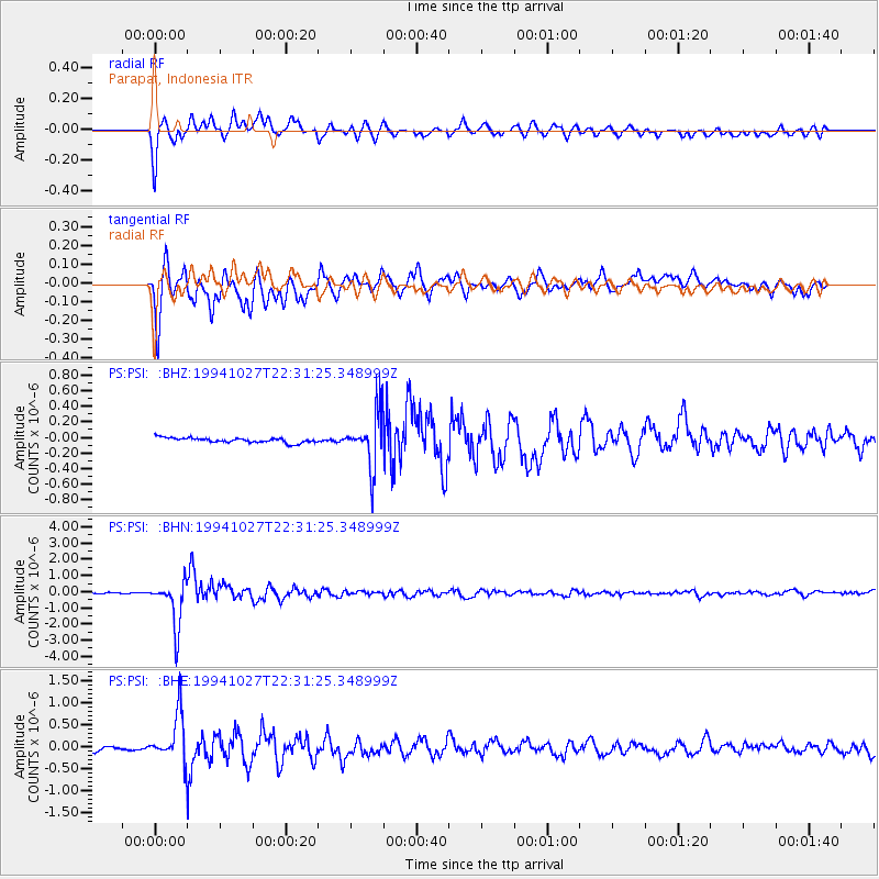
PSI Parapat, Indonesia - Earthquake Result Viewer
*The percent match for this event was below the threshold and hence no stack was calculated.
| Earthquake location: |
South Of Fiji Islands |
| Earthquake latitude/longitude: |
-25.8/179.3 |
| Earthquake time(UTC): |
1994/10/27 (300) 22:20:31 GMT |
| Earthquake Depth: |
549 km |
| Earthquake Magnitude: |
5.9 MB, 6.8 UNKNOWN, 6.7 MW |
| Earthquake Catalog/Contributor: |
WHDF/NEIC |
|
| Network: |
PS Pacific21 |
| Station: |
PSI Parapat, Indonesia |
| Lat/Lon: |
2.69 N/98.92 E |
| Elevation: |
987 m |
|
| Distance: |
82.6 deg |
| Az: |
276.602 deg |
| Baz: |
116.296 deg |
| Ray Param: |
$rayparam |
*The percent match for this event was below the threshold and hence was not used in the summary stack. |
|
| Radial Match: |
84.38244 % |
| Radial Bump: |
400 |
| Transverse Match: |
83.51685 % |
| Transverse Bump: |
400 |
| SOD ConfigId: |
4480 |
| Insert Time: |
2010-02-27 03:25:40.762 +0000 |
| GWidth: |
2.5 |
| Max Bumps: |
400 |
| Tol: |
0.001 |
|
Signal To Noise
| Channel | StoN | STA | LTA |
| PS:PSI: :BHN:19941027T22:31:25.348999Z | 51.86758 | 1.3832783E-6 | 2.666942E-8 |
| PS:PSI: :BHE:19941027T22:31:25.348999Z | 12.288434 | 5.39062E-7 | 4.386743E-8 |
| PS:PSI: :BHZ:19941027T22:31:25.348999Z | 11.067473 | 3.4473473E-7 | 3.114846E-8 |
| Arrivals |
| Ps | |
| PpPs | |
| PsPs/PpSs | |


