You are here: Home > Network List > TA - USArray Transportable Network (new EarthScope stations) Stations List
> Station 109C Camp Elliot, Mirimar, CA, USA > Earthquake Result Viewer
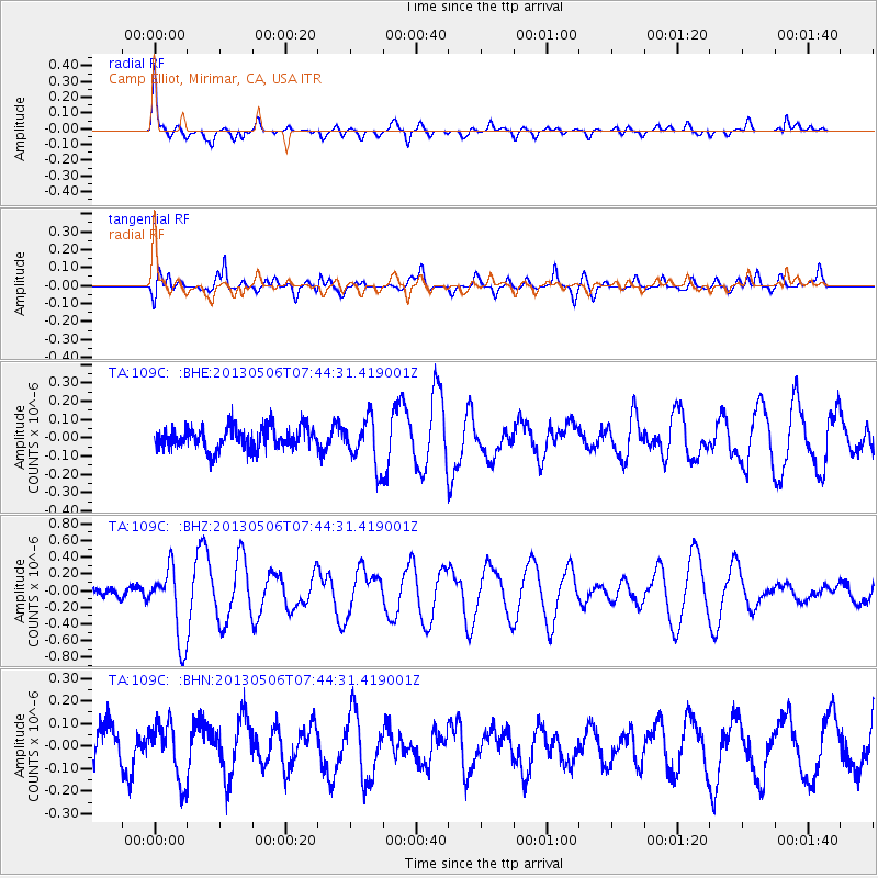
109C Camp Elliot, Mirimar, CA, USA - Earthquake Result Viewer
*The percent match for this event was below the threshold and hence no stack was calculated.
| Earthquake location: |
Fiji Islands Region |
| Earthquake latitude/longitude: |
-21.4/-176.3 |
| Earthquake time(UTC): |
2013/05/06 (126) 07:33:03 GMT |
| Earthquake Depth: |
9.9 km |
| Earthquake Magnitude: |
5.5 MW |
| Earthquake Catalog/Contributor: |
NEIC PDE/NEIC PDE-W |
|
| Network: |
TA USArray Transportable Network (new EarthScope stations) |
| Station: |
109C Camp Elliot, Mirimar, CA, USA |
| Lat/Lon: |
32.89 N/117.11 W |
| Elevation: |
150 m |
|
| Distance: |
78.1 deg |
| Az: |
47.6 deg |
| Baz: |
234.887 deg |
| Ray Param: |
$rayparam |
*The percent match for this event was below the threshold and hence was not used in the summary stack. |
|
| Radial Match: |
71.94873 % |
| Radial Bump: |
400 |
| Transverse Match: |
68.69374 % |
| Transverse Bump: |
400 |
| SOD ConfigId: |
512894 |
| Insert Time: |
2013-09-13 23:10:43.550 +0000 |
| GWidth: |
2.5 |
| Max Bumps: |
400 |
| Tol: |
0.001 |
|
Signal To Noise
| Channel | StoN | STA | LTA |
| TA:109C: :BHZ:20130506T07:44:31.419001Z | 3.1708033 | 4.3120696E-7 | 1.3599296E-7 |
| TA:109C: :BHN:20130506T07:44:31.419001Z | 1.1136116 | 1.2428002E-7 | 1.1160087E-7 |
| TA:109C: :BHE:20130506T07:44:31.419001Z | 2.1564507 | 1.3105891E-7 | 6.0775285E-8 |
| Arrivals |
| Ps | |
| PpPs | |
| PsPs/PpSs | |


