You are here: Home > Network List > PS - Pacific21 Stations List
> Station PSI Parapat, Indonesia > Earthquake Result Viewer
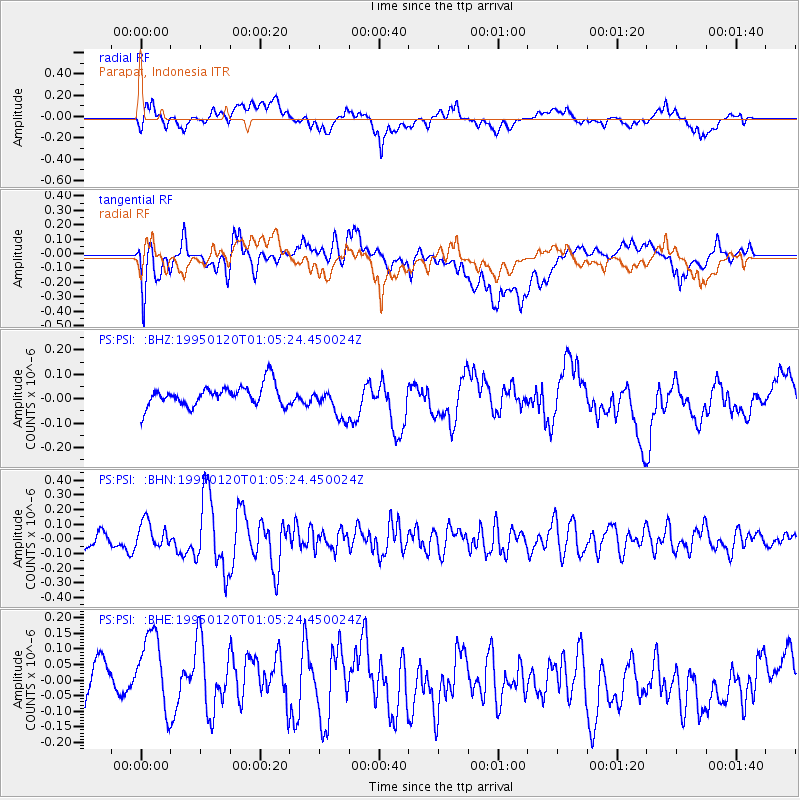
PSI Parapat, Indonesia - Earthquake Result Viewer
*The percent match for this event was below the threshold and hence no stack was calculated.
| Earthquake location: |
Solomon Islands |
| Earthquake latitude/longitude: |
-11.0/162.2 |
| Earthquake time(UTC): |
1995/01/20 (020) 00:55:22 GMT |
| Earthquake Depth: |
28 km |
| Earthquake Magnitude: |
5.6 MB, 5.5 MS, 5.6 UNKNOWN, 5.7 MW |
| Earthquake Catalog/Contributor: |
WHDF/NEIC |
|
| Network: |
PS Pacific21 |
| Station: |
PSI Parapat, Indonesia |
| Lat/Lon: |
2.69 N/98.92 E |
| Elevation: |
987 m |
|
| Distance: |
64.3 deg |
| Az: |
278.344 deg |
| Baz: |
103.426 deg |
| Ray Param: |
$rayparam |
*The percent match for this event was below the threshold and hence was not used in the summary stack. |
|
| Radial Match: |
69.41754 % |
| Radial Bump: |
400 |
| Transverse Match: |
46.669453 % |
| Transverse Bump: |
400 |
| SOD ConfigId: |
4480 |
| Insert Time: |
2010-02-27 03:26:23.196 +0000 |
| GWidth: |
2.5 |
| Max Bumps: |
400 |
| Tol: |
0.001 |
|
Signal To Noise
| Channel | StoN | STA | LTA |
| PS:PSI: :BHN:19950120T01:05:24.450024Z | 1.6945674 | 8.957078E-8 | 5.285761E-8 |
| PS:PSI: :BHE:19950120T01:05:24.450024Z | 1.4687768 | 1.6220864E-7 | 1.104379E-7 |
| PS:PSI: :BHZ:19950120T01:05:24.450024Z | 1.5223699 | 6.6202354E-8 | 4.3486377E-8 |
| Arrivals |
| Ps | |
| PpPs | |
| PsPs/PpSs | |


