You are here: Home > Network List > TA - USArray Transportable Network (new EarthScope stations) Stations List
> Station O03E Paynes Creek, CA, USA > Earthquake Result Viewer
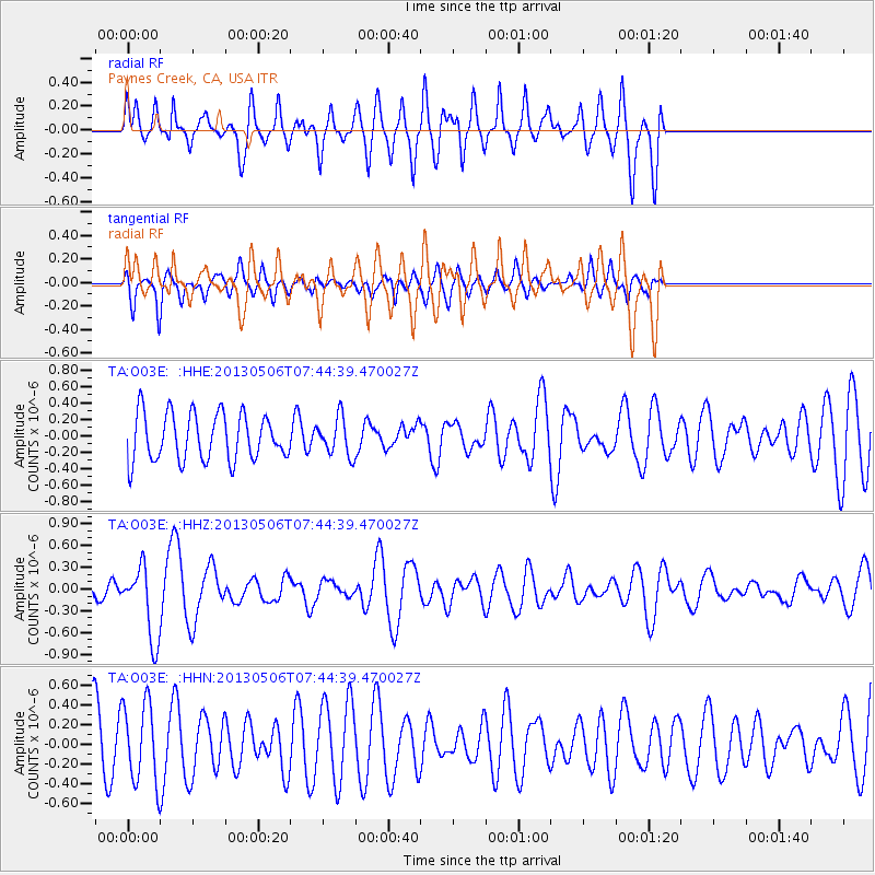
O03E Paynes Creek, CA, USA - Earthquake Result Viewer
*The percent match for this event was below the threshold and hence no stack was calculated.
| Earthquake location: |
Fiji Islands Region |
| Earthquake latitude/longitude: |
-21.4/-176.3 |
| Earthquake time(UTC): |
2013/05/06 (126) 07:33:03 GMT |
| Earthquake Depth: |
9.9 km |
| Earthquake Magnitude: |
5.5 MW |
| Earthquake Catalog/Contributor: |
NEIC PDE/NEIC PDE-W |
|
| Network: |
TA USArray Transportable Network (new EarthScope stations) |
| Station: |
O03E Paynes Creek, CA, USA |
| Lat/Lon: |
40.29 N/121.80 W |
| Elevation: |
967 m |
|
| Distance: |
79.6 deg |
| Az: |
39.275 deg |
| Baz: |
230.481 deg |
| Ray Param: |
$rayparam |
*The percent match for this event was below the threshold and hence was not used in the summary stack. |
|
| Radial Match: |
53.043964 % |
| Radial Bump: |
400 |
| Transverse Match: |
55.767864 % |
| Transverse Bump: |
386 |
| SOD ConfigId: |
512894 |
| Insert Time: |
2013-09-13 23:12:49.177 +0000 |
| GWidth: |
2.5 |
| Max Bumps: |
400 |
| Tol: |
0.001 |
|
Signal To Noise
| Channel | StoN | STA | LTA |
| TA:O03E: :HHZ:20130506T07:44:39.470027Z | 3.426762 | 4.9675367E-7 | 1.4496298E-7 |
| TA:O03E: :HHN:20130506T07:44:39.470027Z | 1.2731651 | 4.0002863E-7 | 3.1420012E-7 |
| TA:O03E: :HHE:20130506T07:44:39.470027Z | 0.7917632 | 2.273983E-7 | 2.8720495E-7 |
| Arrivals |
| Ps | |
| PpPs | |
| PsPs/PpSs | |


