You are here: Home > Network List > US - United States National Seismic Network Stations List
> Station HAWA Hanford, Washington, USA > Earthquake Result Viewer
HAWA Hanford, Washington, USA - Earthquake Result Viewer
*The percent match for this event was below the threshold and hence no stack was calculated.
| Earthquake location: |
Fiji Islands Region |
| Earthquake latitude/longitude: |
-21.4/-176.3 |
| Earthquake time(UTC): |
2013/05/06 (126) 07:33:03 GMT |
| Earthquake Depth: |
9.9 km |
| Earthquake Magnitude: |
5.5 MW |
| Earthquake Catalog/Contributor: |
NEIC PDE/NEIC PDE-W |
|
| Network: |
US United States National Seismic Network |
| Station: |
HAWA Hanford, Washington, USA |
| Lat/Lon: |
46.39 N/119.53 W |
| Elevation: |
364 m |
|
| Distance: |
84.7 deg |
| Az: |
35.547 deg |
| Baz: |
231.526 deg |
| Ray Param: |
$rayparam |
*The percent match for this event was below the threshold and hence was not used in the summary stack. |
|
| Radial Match: |
68.281364 % |
| Radial Bump: |
400 |
| Transverse Match: |
57.51269 % |
| Transverse Bump: |
400 |
| SOD ConfigId: |
512894 |
| Insert Time: |
2013-09-13 23:14:32.847 +0000 |
| GWidth: |
2.5 |
| Max Bumps: |
400 |
| Tol: |
0.001 |
|
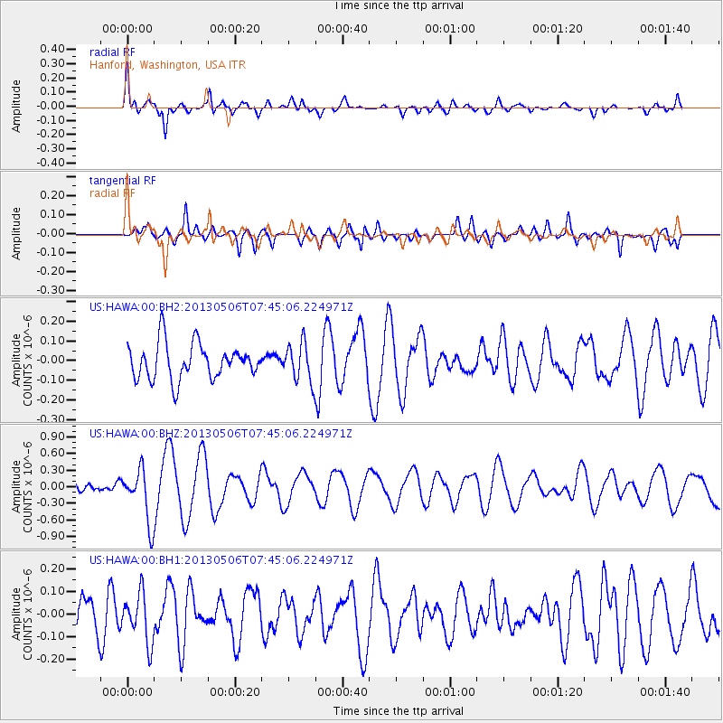
Signal To Noise
| Channel | StoN | STA | LTA |
| US:HAWA:00:BHZ:20130506T07:45:06.224971Z | 4.7105384 | 4.835256E-7 | 1.02647626E-7 |
| US:HAWA:00:BH1:20130506T07:45:06.224971Z | 1.5784286 | 1.1031145E-7 | 6.988687E-8 |
| US:HAWA:00:BH2:20130506T07:45:06.224971Z | 1.097068 | 9.880193E-8 | 9.005999E-8 |
| Arrivals |
| Ps | |
| PpPs | |
| PsPs/PpSs | |


