You are here: Home > Network List > UU - University of Utah Regional Network Stations List
> Station SZCU Shurtz Canyon, UT, USA > Earthquake Result Viewer
SZCU Shurtz Canyon, UT, USA - Earthquake Result Viewer
| Earthquake location: |
Fiji Islands Region |
| Earthquake latitude/longitude: |
-21.4/-176.3 |
| Earthquake time(UTC): |
2013/05/06 (126) 07:33:03 GMT |
| Earthquake Depth: |
9.9 km |
| Earthquake Magnitude: |
5.5 MW |
| Earthquake Catalog/Contributor: |
NEIC PDE/NEIC PDE-W |
|
| Network: |
UU University of Utah Regional Network |
| Station: |
SZCU Shurtz Canyon, UT, USA |
| Lat/Lon: |
37.60 N/113.09 W |
| Elevation: |
2026 m |
|
| Distance: |
83.5 deg |
| Az: |
45.533 deg |
| Baz: |
236.867 deg |
| Ray Param: |
0.046159923 |
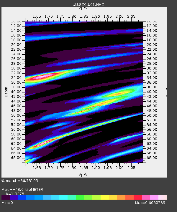
| Estimated Moho Depth: |
48.0 km |
| Estimated Crust Vp/Vs: |
1.84 |
| Assumed Crust Vp: |
6.194 km/s |
| Estimated Crust Vs: |
3.371 km/s |
| Estimated Crust Poisson's Ratio: |
0.29 |
|
| Radial Match: |
86.78193 % |
| Radial Bump: |
290 |
| Transverse Match: |
57.84024 % |
| Transverse Bump: |
400 |
| SOD ConfigId: |
512894 |
| Insert Time: |
2013-09-13 23:16:27.667 +0000 |
| GWidth: |
2.5 |
| Max Bumps: |
400 |
| Tol: |
0.001 |
|

Signal To Noise
| Channel | StoN | STA | LTA |
| UU:SZCU:01:HHZ:20130506T07:44:59.939998Z | 4.7324286 | 8.498728E-9 | 1.795849E-9 |
| UU:SZCU:01:HHN:20130506T07:44:59.939998Z | 1.2781935 | 2.2981295E-9 | 1.7979512E-9 |
| UU:SZCU:01:HHE:20130506T07:44:59.939998Z | 1.7838725 | 3.0719765E-9 | 1.722083E-9 |
| Arrivals |
| Ps | 6.6 SECOND |
| PpPs | 21 SECOND |
| PsPs/PpSs | 28 SECOND |


