You are here: Home > Network List > UW - Pacific Northwest Regional Seismic Network Stations List
> Station HOOD Mt Hood Meadows, OR CREST BB SMO > Earthquake Result Viewer
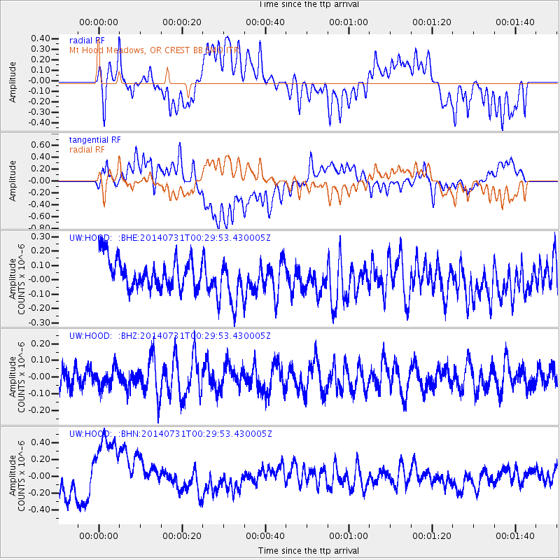
HOOD Mt Hood Meadows, OR CREST BB SMO - Earthquake Result Viewer
*The percent match for this event was below the threshold and hence no stack was calculated.
| Earthquake location: |
South Of Fiji Islands |
| Earthquake latitude/longitude: |
-23.5/-176.4 |
| Earthquake time(UTC): |
2014/07/31 (212) 00:17:54 GMT |
| Earthquake Depth: |
38 km |
| Earthquake Magnitude: |
5.4 MW, 5.3 mb, 4.9 MS |
| Earthquake Catalog/Contributor: |
ISC/ISC |
|
| Network: |
UW Pacific Northwest Regional Seismic Network |
| Station: |
HOOD Mt Hood Meadows, OR CREST BB SMO |
| Lat/Lon: |
45.32 N/121.65 W |
| Elevation: |
1520 m |
|
| Distance: |
84.7 deg |
| Az: |
35.349 deg |
| Baz: |
228.837 deg |
| Ray Param: |
$rayparam |
*The percent match for this event was below the threshold and hence was not used in the summary stack. |
|
| Radial Match: |
42.999454 % |
| Radial Bump: |
400 |
| Transverse Match: |
39.793945 % |
| Transverse Bump: |
400 |
| SOD ConfigId: |
3390531 |
| Insert Time: |
2019-04-13 02:53:10.329 +0000 |
| GWidth: |
2.5 |
| Max Bumps: |
400 |
| Tol: |
0.001 |
|
Signal To Noise
| Channel | StoN | STA | LTA |
| UW:HOOD: :BHZ:20140731T00:29:53.430005Z | 0.83567905 | 5.9721756E-8 | 7.146494E-8 |
| UW:HOOD: :BHN:20140731T00:29:53.430005Z | 4.8923597 | 4.713222E-7 | 9.6338425E-8 |
| UW:HOOD: :BHE:20140731T00:29:53.430005Z | 1.6239697 | 1.6573675E-7 | 1.0205656E-7 |
| Arrivals |
| Ps | |
| PpPs | |
| PsPs/PpSs | |


