You are here: Home > Network List > TA - USArray Transportable Network (new EarthScope stations) Stations List
> Station A04D Lummi Island, WA, USA > Earthquake Result Viewer
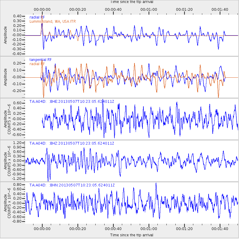
A04D Lummi Island, WA, USA - Earthquake Result Viewer
*The percent match for this event was below the threshold and hence no stack was calculated.
| Earthquake location: |
South Of Fiji Islands |
| Earthquake latitude/longitude: |
-19.6/175.1 |
| Earthquake time(UTC): |
2013/05/07 (127) 10:10:48 GMT |
| Earthquake Depth: |
11 km |
| Earthquake Magnitude: |
5.6 MB, 5.7 MS, 6.0 MW, 5.9 MW |
| Earthquake Catalog/Contributor: |
WHDF/NEIC |
|
| Network: |
TA USArray Transportable Network (new EarthScope stations) |
| Station: |
A04D Lummi Island, WA, USA |
| Lat/Lon: |
48.72 N/122.71 W |
| Elevation: |
13 m |
|
| Distance: |
87.7 deg |
| Az: |
35.91 deg |
| Baz: |
236.601 deg |
| Ray Param: |
$rayparam |
*The percent match for this event was below the threshold and hence was not used in the summary stack. |
|
| Radial Match: |
46.13317 % |
| Radial Bump: |
400 |
| Transverse Match: |
58.972866 % |
| Transverse Bump: |
400 |
| SOD ConfigId: |
512894 |
| Insert Time: |
2013-09-13 23:33:22.287 +0000 |
| GWidth: |
2.5 |
| Max Bumps: |
400 |
| Tol: |
0.001 |
|
Signal To Noise
| Channel | StoN | STA | LTA |
| TA:A04D: :BHZ:20130507T10:23:05.624011Z | 4.1306367 | 5.3056533E-7 | 1.2844639E-7 |
| TA:A04D: :BHN:20130507T10:23:05.624011Z | 0.73655003 | 1.9021552E-7 | 2.58252E-7 |
| TA:A04D: :BHE:20130507T10:23:05.624011Z | 1.4288484 | 3.068314E-7 | 2.1474034E-7 |
| Arrivals |
| Ps | |
| PpPs | |
| PsPs/PpSs | |


