You are here: Home > Network List > US - United States National Seismic Network Stations List
> Station HAWA Hanford, Washington, USA > Earthquake Result Viewer
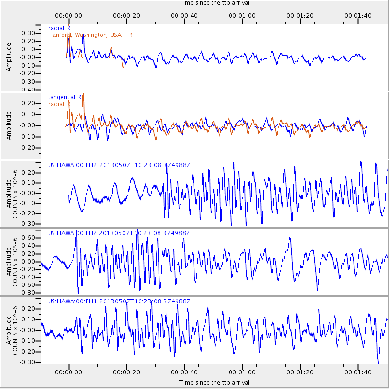
HAWA Hanford, Washington, USA - Earthquake Result Viewer
*The percent match for this event was below the threshold and hence no stack was calculated.
| Earthquake location: |
South Of Fiji Islands |
| Earthquake latitude/longitude: |
-19.6/175.1 |
| Earthquake time(UTC): |
2013/05/07 (127) 10:10:48 GMT |
| Earthquake Depth: |
11 km |
| Earthquake Magnitude: |
5.6 MB, 5.7 MS, 6.0 MW, 5.9 MW |
| Earthquake Catalog/Contributor: |
WHDF/NEIC |
|
| Network: |
US United States National Seismic Network |
| Station: |
HAWA Hanford, Washington, USA |
| Lat/Lon: |
46.39 N/119.53 W |
| Elevation: |
364 m |
|
| Distance: |
88.3 deg |
| Az: |
39.028 deg |
| Baz: |
239.047 deg |
| Ray Param: |
$rayparam |
*The percent match for this event was below the threshold and hence was not used in the summary stack. |
|
| Radial Match: |
67.85298 % |
| Radial Bump: |
400 |
| Transverse Match: |
63.977875 % |
| Transverse Bump: |
400 |
| SOD ConfigId: |
512894 |
| Insert Time: |
2013-09-13 23:34:45.978 +0000 |
| GWidth: |
2.5 |
| Max Bumps: |
400 |
| Tol: |
0.001 |
|
Signal To Noise
| Channel | StoN | STA | LTA |
| US:HAWA:00:BHZ:20130507T10:23:08.374988Z | 3.3861973 | 3.6436066E-7 | 1.0760172E-7 |
| US:HAWA:00:BH1:20130507T10:23:08.374988Z | 1.5149479 | 7.501698E-8 | 4.9517862E-8 |
| US:HAWA:00:BH2:20130507T10:23:08.374988Z | 1.5995338 | 1.1863653E-7 | 7.416944E-8 |
| Arrivals |
| Ps | |
| PpPs | |
| PsPs/PpSs | |


