You are here: Home > Network List > UW - Pacific Northwest Regional Seismic Network Stations List
> Station LTY Liberty (broad-band) > Earthquake Result Viewer
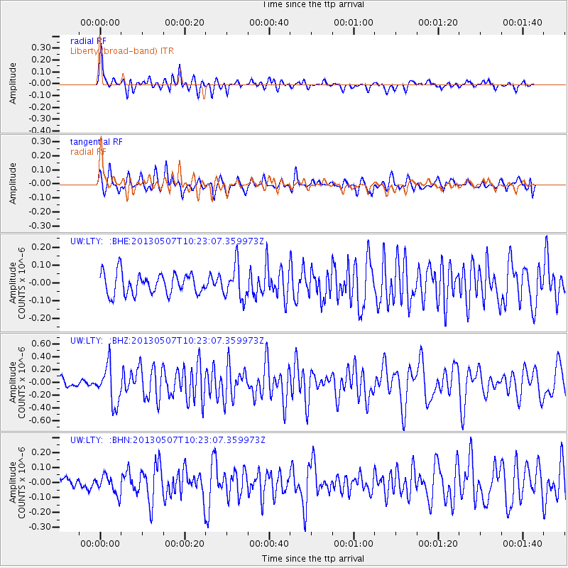
LTY Liberty (broad-band) - Earthquake Result Viewer
*The percent match for this event was below the threshold and hence no stack was calculated.
| Earthquake location: |
South Of Fiji Islands |
| Earthquake latitude/longitude: |
-19.6/175.1 |
| Earthquake time(UTC): |
2013/05/07 (127) 10:10:48 GMT |
| Earthquake Depth: |
11 km |
| Earthquake Magnitude: |
5.6 MB, 5.7 MS, 6.0 MW, 5.9 MW |
| Earthquake Catalog/Contributor: |
WHDF/NEIC |
|
| Network: |
UW Pacific Northwest Regional Seismic Network |
| Station: |
LTY Liberty (broad-band) |
| Lat/Lon: |
47.26 N/120.66 W |
| Elevation: |
970 m |
|
| Distance: |
88.0 deg |
| Az: |
37.885 deg |
| Baz: |
238.187 deg |
| Ray Param: |
$rayparam |
*The percent match for this event was below the threshold and hence was not used in the summary stack. |
|
| Radial Match: |
70.6569 % |
| Radial Bump: |
400 |
| Transverse Match: |
60.297623 % |
| Transverse Bump: |
400 |
| SOD ConfigId: |
512894 |
| Insert Time: |
2013-09-13 23:36:54.178 +0000 |
| GWidth: |
2.5 |
| Max Bumps: |
400 |
| Tol: |
0.001 |
|
Signal To Noise
| Channel | StoN | STA | LTA |
| UW:LTY: :BHZ:20130507T10:23:07.359973Z | 4.6956115 | 3.0654937E-7 | 6.5284226E-8 |
| UW:LTY: :BHN:20130507T10:23:07.359973Z | 0.9160986 | 6.3024565E-8 | 6.879671E-8 |
| UW:LTY: :BHE:20130507T10:23:07.359973Z | 1.6478002 | 9.657385E-8 | 5.8607746E-8 |
| Arrivals |
| Ps | |
| PpPs | |
| PsPs/PpSs | |


