You are here: Home > Network List > IU - Global Seismograph Network (GSN - IRIS/USGS) Stations List
> Station KMBO Kilima Mbogo, Kenya > Earthquake Result Viewer
KMBO Kilima Mbogo, Kenya - Earthquake Result Viewer
| Earthquake location: |
Southern Iran |
| Earthquake latitude/longitude: |
26.6/57.8 |
| Earthquake time(UTC): |
2013/05/11 (131) 02:08:08 GMT |
| Earthquake Depth: |
15 km |
| Earthquake Magnitude: |
5.9 MB, 6.2 MS, 6.1 MW, 6.1 MW |
| Earthquake Catalog/Contributor: |
WHDF/NEIC |
|
| Network: |
IU Global Seismograph Network (GSN - IRIS/USGS) |
| Station: |
KMBO Kilima Mbogo, Kenya |
| Lat/Lon: |
1.13 S/37.25 E |
| Elevation: |
1950 m |
|
| Distance: |
33.9 deg |
| Az: |
218.922 deg |
| Baz: |
34.251 deg |
| Ray Param: |
0.07798351 |
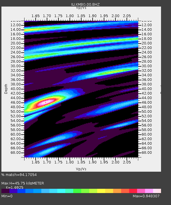
| Estimated Moho Depth: |
45.75 km |
| Estimated Crust Vp/Vs: |
1.69 |
| Assumed Crust Vp: |
6.601 km/s |
| Estimated Crust Vs: |
3.9 km/s |
| Estimated Crust Poisson's Ratio: |
0.23 |
|
| Radial Match: |
94.17054 % |
| Radial Bump: |
310 |
| Transverse Match: |
75.50878 % |
| Transverse Bump: |
400 |
| SOD ConfigId: |
512894 |
| Insert Time: |
2013-09-14 00:07:57.670 +0000 |
| GWidth: |
2.5 |
| Max Bumps: |
400 |
| Tol: |
0.001 |
|

Signal To Noise
| Channel | StoN | STA | LTA |
| IU:KMBO:00:BHZ:20130511T02:14:19.968994Z | 1.1134056 | 6.852905E-8 | 6.1549045E-8 |
| IU:KMBO:00:BH1:20130511T02:14:19.968994Z | 1.2948068 | 6.3457605E-8 | 4.9009323E-8 |
| IU:KMBO:00:BH2:20130511T02:14:19.968994Z | 0.74984694 | 4.1750905E-8 | 5.5679234E-8 |
| Arrivals |
| Ps | 5.2 SECOND |
| PpPs | 17 SECOND |
| PsPs/PpSs | 22 SECOND |


