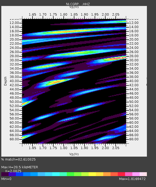
CGRP Cima Grappa - Earthquake Result Viewer
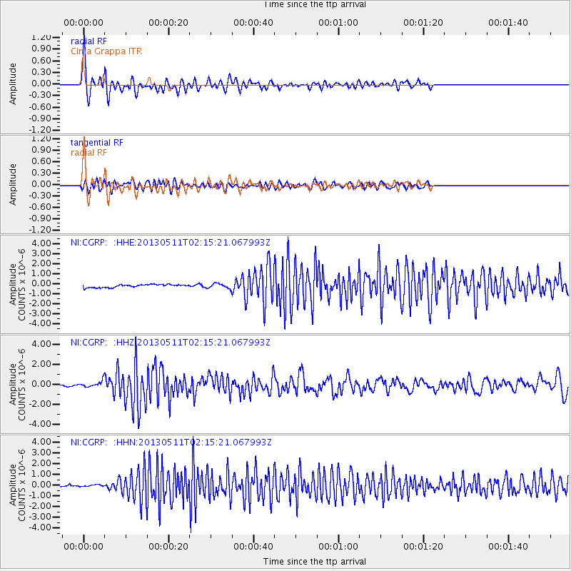
Earthquake location: Southern Iran
Earthquake latitude/longitude: 26.6/57.8
Earthquake time(UTC): 2013/05/11 (131) 02:08:08 GMT
Earthquake Depth: 15 km
Earthquake Magnitude: 5.9 MB, 6.2 MS, 6.1 MW, 6.1 MW
Earthquake Catalog/Contributor: WHDF/NEIC
Network: NI North-East Italy Broadband Network
Station: CGRP Cima Grappa
Lat/Lon: 45.88 N/11.80 E
Elevation: 1757 m
Distance: 41.1 deg
Az: 310.236 deg
Baz: 101.824 deg
Ray Param: 0.07396737
Estimated Moho Depth: 28.5 km
Estimated Crust Vp/Vs: 2.08
Assumed Crust Vp: 6.155 km/s
Estimated Crust Vs: 2.956 km/s
Estimated Crust Poisson's Ratio: 0.35
Radial Match: 82.610825 %
Radial Bump: 400
Transverse Match: 74.61818 %
Transverse Bump: 400
SOD ConfigId: 512894
Insert Time: 2013-09-14 00:10:00.190 +0000
GWidth: 2.5
Max Bumps: 400
Tol: 0.001

Signal To Noise

ChannelStoNSTALTA
NI:CGRP: :HHZ:20130511T02:15:21.067993Z3.2752362.992127E-79.135608E-8
NI:CGRP: :HHN:20130511T02:15:21.067993Z1.23978771.0665056E-78.602324E-8
NI:CGRP: :HHE:20130511T02:15:21.067993Z1.55466252.330826E-71.499249E-7
Arrivals
Ps5.3 SECOND
PpPs14 SECOND
PsPs/PpSs19 SECOND