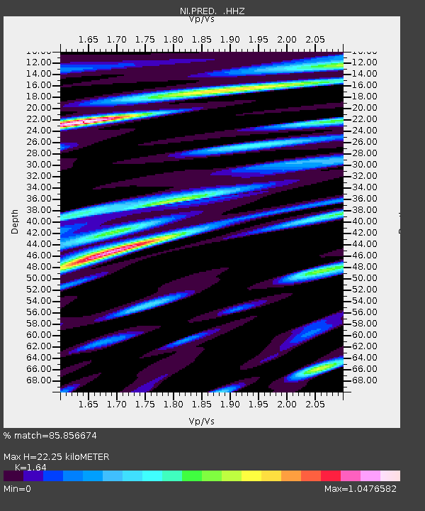
PRED Cave del Predil - Earthquake Result Viewer

Earthquake location: Southern Iran
Earthquake latitude/longitude: 26.6/57.8
Earthquake time(UTC): 2013/05/11 (131) 02:08:08 GMT
Earthquake Depth: 15 km
Earthquake Magnitude: 5.9 MB, 6.2 MS, 6.1 MW, 6.1 MW
Earthquake Catalog/Contributor: WHDF/NEIC
Network: NI North-East Italy Broadband Network
Station: PRED Cave del Predil
Lat/Lon: 46.44 N/13.56 E
Elevation: 879 m
Distance: 40.1 deg
Az: 311.499 deg
Baz: 104.049 deg
Ray Param: 0.07459286
Estimated Moho Depth: 22.25 km
Estimated Crust Vp/Vs: 1.64
Assumed Crust Vp: 6.35 km/s
Estimated Crust Vs: 3.872 km/s
Estimated Crust Poisson's Ratio: 0.20
Radial Match: 85.856674 %
Radial Bump: 400
Transverse Match: 80.76395 %
Transverse Bump: 400
SOD ConfigId: 512894
Insert Time: 2013-09-14 00:10:13.836 +0000
GWidth: 2.5
Max Bumps: 400
Tol: 0.001

Signal To Noise

ChannelStoNSTALTA
NI:PRED: :HHZ:20130511T02:15:12.268005Z3.22641282.179093E-76.753919E-8
NI:PRED: :HHN:20130511T02:15:12.268005Z0.710121455.583413E-87.8626165E-8
NI:PRED: :HHE:20130511T02:15:12.268005Z4.40257931.4706838E-73.3405048E-8
Arrivals
Ps2.4 SECOND
PpPs8.6 SECOND
PsPs/PpSs11 SECOND