You are here: Home > Network List > AK - Alaska Regional Network Stations List
> Station RDOG Red Dog Mine, AK, USA > Earthquake Result Viewer
RDOG Red Dog Mine, AK, USA - Earthquake Result Viewer
| Earthquake location: |
Tonga Islands |
| Earthquake latitude/longitude: |
-18.0/-175.1 |
| Earthquake time(UTC): |
2013/05/11 (131) 20:46:57 GMT |
| Earthquake Depth: |
213 km |
| Earthquake Magnitude: |
5.8 MB, 6.4 MW, 6.4 MW |
| Earthquake Catalog/Contributor: |
WHDF/NEIC |
|
| Network: |
AK Alaska Regional Network |
| Station: |
RDOG Red Dog Mine, AK, USA |
| Lat/Lon: |
68.05 N/162.90 W |
| Elevation: |
421 m |
|
| Distance: |
86.2 deg |
| Az: |
4.567 deg |
| Baz: |
191.632 deg |
| Ray Param: |
0.043689154 |
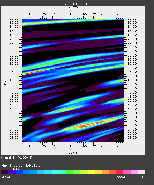
| Estimated Moho Depth: |
61.25 km |
| Estimated Crust Vp/Vs: |
1.93 |
| Assumed Crust Vp: |
5.906 km/s |
| Estimated Crust Vs: |
3.052 km/s |
| Estimated Crust Poisson's Ratio: |
0.32 |
|
| Radial Match: |
96.00441 % |
| Radial Bump: |
366 |
| Transverse Match: |
86.165016 % |
| Transverse Bump: |
400 |
| SOD ConfigId: |
512894 |
| Insert Time: |
2013-09-14 00:28:32.819 +0000 |
| GWidth: |
2.5 |
| Max Bumps: |
400 |
| Tol: |
0.001 |
|

Signal To Noise
| Channel | StoN | STA | LTA |
| AK:RDOG: :BHZ:20130511T20:58:43.707981Z | 37.772514 | 1.5686169E-6 | 4.1527997E-8 |
| AK:RDOG: :BHN:20130511T20:58:43.707981Z | 9.239013 | 4.3639469E-7 | 4.723391E-8 |
| AK:RDOG: :BHE:20130511T20:58:43.707981Z | 4.92366 | 2.9711038E-7 | 6.0343396E-8 |
| Arrivals |
| Ps | 9.9 SECOND |
| PpPs | 30 SECOND |
| PsPs/PpSs | 40 SECOND |


