You are here: Home > Network List > AK - Alaska Regional Network Stations List
> Station WAT1 Susitna Watana 1, AK, USA > Earthquake Result Viewer
WAT1 Susitna Watana 1, AK, USA - Earthquake Result Viewer
| Earthquake location: |
Tonga Islands |
| Earthquake latitude/longitude: |
-18.0/-175.1 |
| Earthquake time(UTC): |
2013/05/11 (131) 20:46:57 GMT |
| Earthquake Depth: |
213 km |
| Earthquake Magnitude: |
5.8 MB, 6.4 MW, 6.4 MW |
| Earthquake Catalog/Contributor: |
WHDF/NEIC |
|
| Network: |
AK Alaska Regional Network |
| Station: |
WAT1 Susitna Watana 1, AK, USA |
| Lat/Lon: |
62.83 N/148.55 W |
| Elevation: |
722 m |
|
| Distance: |
83.2 deg |
| Az: |
11.929 deg |
| Baz: |
205.377 deg |
| Ray Param: |
0.045837298 |
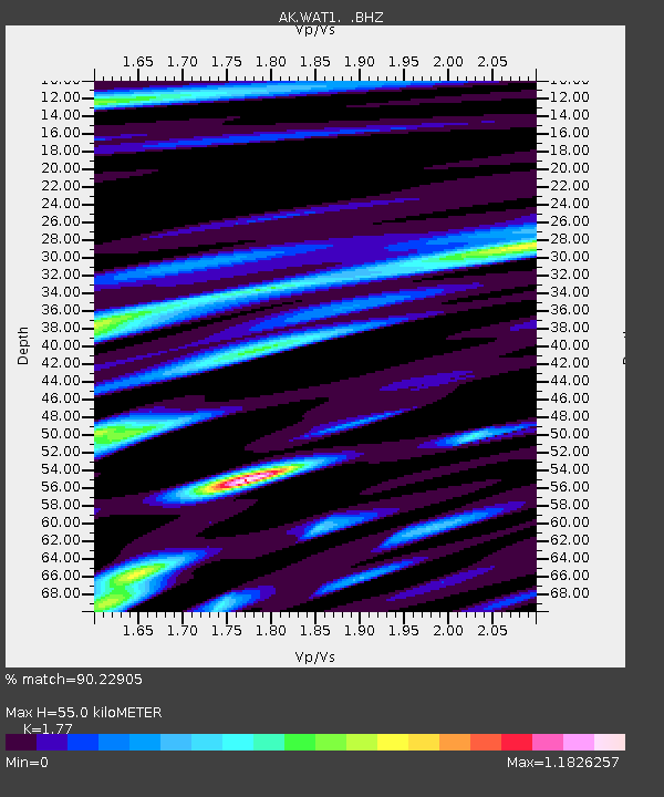
| Estimated Moho Depth: |
55.0 km |
| Estimated Crust Vp/Vs: |
1.77 |
| Assumed Crust Vp: |
6.566 km/s |
| Estimated Crust Vs: |
3.71 km/s |
| Estimated Crust Poisson's Ratio: |
0.27 |
|
| Radial Match: |
90.22905 % |
| Radial Bump: |
400 |
| Transverse Match: |
86.490845 % |
| Transverse Bump: |
400 |
| SOD ConfigId: |
512894 |
| Insert Time: |
2013-09-14 00:29:05.464 +0000 |
| GWidth: |
2.5 |
| Max Bumps: |
400 |
| Tol: |
0.001 |
|

Signal To Noise
| Channel | StoN | STA | LTA |
| AK:WAT1: :BHZ:20130511T20:58:28.608005Z | 26.12446 | 1.8217012E-6 | 6.973163E-8 |
| AK:WAT1: :BHN:20130511T20:58:28.608005Z | 13.401515 | 6.115195E-7 | 4.5630625E-8 |
| AK:WAT1: :BHE:20130511T20:58:28.608005Z | 6.2662106 | 3.535924E-7 | 5.642843E-8 |
| Arrivals |
| Ps | 6.6 SECOND |
| PpPs | 23 SECOND |
| PsPs/PpSs | 29 SECOND |


