You are here: Home > Network List > AK - Alaska Regional Network Stations List
> Station WAT2 Susitna Watana 2, AK, USA > Earthquake Result Viewer
WAT2 Susitna Watana 2, AK, USA - Earthquake Result Viewer
| Earthquake location: |
Tonga Islands |
| Earthquake latitude/longitude: |
-18.0/-175.1 |
| Earthquake time(UTC): |
2013/05/11 (131) 20:46:57 GMT |
| Earthquake Depth: |
213 km |
| Earthquake Magnitude: |
5.8 MB, 6.4 MW, 6.4 MW |
| Earthquake Catalog/Contributor: |
WHDF/NEIC |
|
| Network: |
AK Alaska Regional Network |
| Station: |
WAT2 Susitna Watana 2, AK, USA |
| Lat/Lon: |
62.96 N/148.59 W |
| Elevation: |
1366 m |
|
| Distance: |
83.3 deg |
| Az: |
11.857 deg |
| Baz: |
205.337 deg |
| Ray Param: |
0.04575816 |
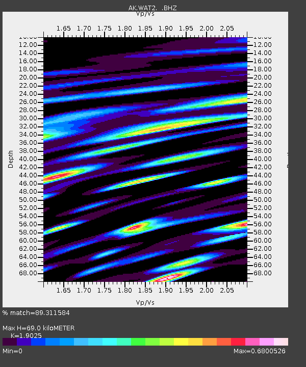
| Estimated Moho Depth: |
69.0 km |
| Estimated Crust Vp/Vs: |
1.90 |
| Assumed Crust Vp: |
6.566 km/s |
| Estimated Crust Vs: |
3.451 km/s |
| Estimated Crust Poisson's Ratio: |
0.31 |
|
| Radial Match: |
89.311584 % |
| Radial Bump: |
400 |
| Transverse Match: |
80.54428 % |
| Transverse Bump: |
400 |
| SOD ConfigId: |
512894 |
| Insert Time: |
2013-09-14 00:29:06.057 +0000 |
| GWidth: |
2.5 |
| Max Bumps: |
400 |
| Tol: |
0.001 |
|

Signal To Noise
| Channel | StoN | STA | LTA |
| AK:WAT2: :BHZ:20130511T20:58:29.168003Z | 33.3784 | 1.8539647E-6 | 5.5543847E-8 |
| AK:WAT2: :BHN:20130511T20:58:29.168003Z | 12.362768 | 6.5967805E-7 | 5.336006E-8 |
| AK:WAT2: :BHE:20130511T20:58:29.168003Z | 7.777924 | 4.599064E-7 | 5.912971E-8 |
| Arrivals |
| Ps | 9.7 SECOND |
| PpPs | 30 SECOND |
| PsPs/PpSs | 39 SECOND |


