You are here: Home > Network List > CC - Cascade Chain Volcano Monitoring Stations List
> Station TMBU Tom Butte, Newberry, OR > Earthquake Result Viewer
TMBU Tom Butte, Newberry, OR - Earthquake Result Viewer
| Earthquake location: |
Tonga Islands |
| Earthquake latitude/longitude: |
-18.0/-175.1 |
| Earthquake time(UTC): |
2013/05/11 (131) 20:46:57 GMT |
| Earthquake Depth: |
213 km |
| Earthquake Magnitude: |
5.8 MB, 6.4 MW, 6.4 MW |
| Earthquake Catalog/Contributor: |
WHDF/NEIC |
|
| Network: |
CC Cascade Chain Volcano Monitoring |
| Station: |
TMBU Tom Butte, Newberry, OR |
| Lat/Lon: |
43.60 N/121.14 W |
| Elevation: |
1743 m |
|
| Distance: |
78.7 deg |
| Az: |
36.804 deg |
| Baz: |
231.715 deg |
| Ray Param: |
0.048928898 |
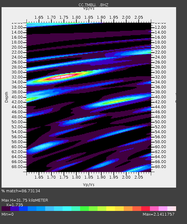
| Estimated Moho Depth: |
31.75 km |
| Estimated Crust Vp/Vs: |
1.74 |
| Assumed Crust Vp: |
6.597 km/s |
| Estimated Crust Vs: |
3.803 km/s |
| Estimated Crust Poisson's Ratio: |
0.25 |
|
| Radial Match: |
86.73134 % |
| Radial Bump: |
400 |
| Transverse Match: |
72.97474 % |
| Transverse Bump: |
400 |
| SOD ConfigId: |
512894 |
| Insert Time: |
2013-09-14 00:33:48.899 +0000 |
| GWidth: |
2.5 |
| Max Bumps: |
400 |
| Tol: |
0.001 |
|

Signal To Noise
| Channel | StoN | STA | LTA |
| CC:TMBU: :BHZ:20130511T20:58:04.920017Z | 11.318648 | 1.4523555E-6 | 1.2831526E-7 |
| CC:TMBU: :BHN:20130511T20:58:04.920017Z | 1.045692 | 4.369007E-7 | 4.1781013E-7 |
| CC:TMBU: :BHE:20130511T20:58:04.920017Z | 2.2899396 | 5.197833E-7 | 2.269856E-7 |
| Arrivals |
| Ps | 3.6 SECOND |
| PpPs | 13 SECOND |
| PsPs/PpSs | 16 SECOND |


