You are here: Home > Network List > IU - Global Seismograph Network (GSN - IRIS/USGS) Stations List
> Station GUMO Guam, Mariana Islands > Earthquake Result Viewer
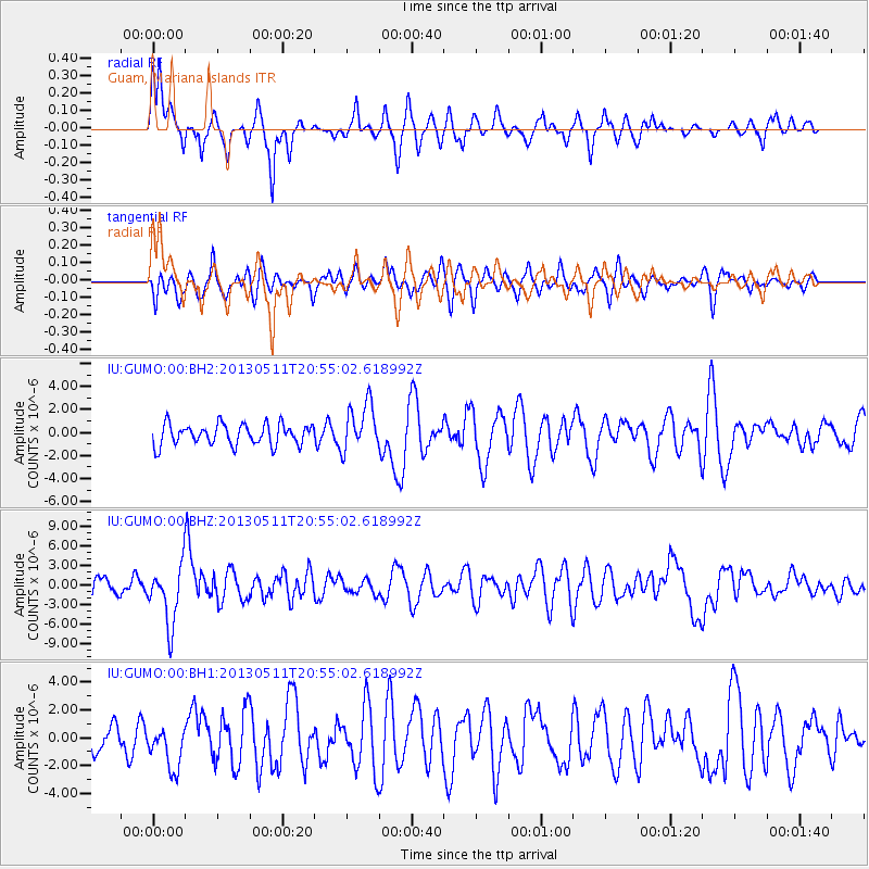
GUMO Guam, Mariana Islands - Earthquake Result Viewer
*The percent match for this event was below the threshold and hence no stack was calculated.
| Earthquake location: |
Tonga Islands |
| Earthquake latitude/longitude: |
-18.0/-175.1 |
| Earthquake time(UTC): |
2013/05/11 (131) 20:46:57 GMT |
| Earthquake Depth: |
213 km |
| Earthquake Magnitude: |
5.8 MB, 6.4 MW, 6.4 MW |
| Earthquake Catalog/Contributor: |
WHDF/NEIC |
|
| Network: |
IU Global Seismograph Network (GSN - IRIS/USGS) |
| Station: |
GUMO Guam, Mariana Islands |
| Lat/Lon: |
13.59 N/144.87 E |
| Elevation: |
170 m |
|
| Distance: |
50.4 deg |
| Az: |
305.769 deg |
| Baz: |
127.415 deg |
| Ray Param: |
$rayparam |
*The percent match for this event was below the threshold and hence was not used in the summary stack. |
|
| Radial Match: |
78.594246 % |
| Radial Bump: |
341 |
| Transverse Match: |
54.08697 % |
| Transverse Bump: |
400 |
| SOD ConfigId: |
512894 |
| Insert Time: |
2013-09-14 00:38:40.837 +0000 |
| GWidth: |
2.5 |
| Max Bumps: |
400 |
| Tol: |
0.001 |
|
Signal To Noise
| Channel | StoN | STA | LTA |
| IU:GUMO:00:BHZ:20130511T20:55:02.618992Z | 3.940345 | 4.527805E-6 | 1.1490885E-6 |
| IU:GUMO:00:BH1:20130511T20:55:02.618992Z | 1.2492076 | 1.5297566E-6 | 1.2245815E-6 |
| IU:GUMO:00:BH2:20130511T20:55:02.618992Z | 2.2750275 | 2.0573982E-6 | 9.0433997E-7 |
| Arrivals |
| Ps | |
| PpPs | |
| PsPs/PpSs | |


