You are here: Home > Network List > NN - Western Great Basin/Eastern Sierra Nevada Stations List
> Station RUB Rubicon Trail, California w84 > Earthquake Result Viewer
RUB Rubicon Trail, California w84 - Earthquake Result Viewer
| Earthquake location: |
Tonga Islands |
| Earthquake latitude/longitude: |
-18.0/-175.1 |
| Earthquake time(UTC): |
2013/05/11 (131) 20:46:57 GMT |
| Earthquake Depth: |
213 km |
| Earthquake Magnitude: |
5.8 MB, 6.4 MW, 6.4 MW |
| Earthquake Catalog/Contributor: |
WHDF/NEIC |
|
| Network: |
NN Western Great Basin/Eastern Sierra Nevada |
| Station: |
RUB Rubicon Trail, California w84 |
| Lat/Lon: |
39.05 N/120.15 W |
| Elevation: |
2045 m |
|
| Distance: |
76.5 deg |
| Az: |
40.96 deg |
| Baz: |
233.26 deg |
| Ray Param: |
0.050392315 |
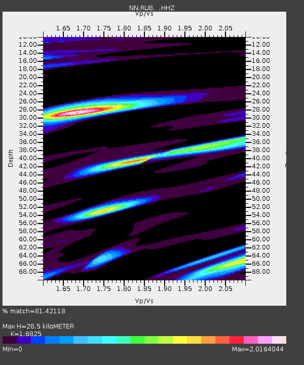
| Estimated Moho Depth: |
28.5 km |
| Estimated Crust Vp/Vs: |
1.68 |
| Assumed Crust Vp: |
6.597 km/s |
| Estimated Crust Vs: |
3.921 km/s |
| Estimated Crust Poisson's Ratio: |
0.23 |
|
| Radial Match: |
81.42118 % |
| Radial Bump: |
400 |
| Transverse Match: |
76.49518 % |
| Transverse Bump: |
400 |
| SOD ConfigId: |
512894 |
| Insert Time: |
2013-09-14 00:41:19.031 +0000 |
| GWidth: |
2.5 |
| Max Bumps: |
400 |
| Tol: |
0.001 |
|

Signal To Noise
| Channel | StoN | STA | LTA |
| NN:RUB: :HHZ:20130511T20:57:52.915012Z | 8.873009 | 8.1027497E-7 | 9.131907E-8 |
| NN:RUB: :HHN:20130511T20:57:52.915012Z | 0.9698648 | 1.6787563E-7 | 1.7309178E-7 |
| NN:RUB: :HHE:20130511T20:57:52.915012Z | 2.1439517 | 4.0097493E-7 | 1.870261E-7 |
| Arrivals |
| Ps | 3.1 SECOND |
| PpPs | 11 SECOND |
| PsPs/PpSs | 14 SECOND |


