You are here: Home > Network List > NN - Western Great Basin/Eastern Sierra Nevada Stations List
> Station RYN Ryan, Nevada w84,gps > Earthquake Result Viewer
RYN Ryan, Nevada w84,gps - Earthquake Result Viewer
| Earthquake location: |
Tonga Islands |
| Earthquake latitude/longitude: |
-18.0/-175.1 |
| Earthquake time(UTC): |
2013/05/11 (131) 20:46:57 GMT |
| Earthquake Depth: |
213 km |
| Earthquake Magnitude: |
5.8 MB, 6.4 MW, 6.4 MW |
| Earthquake Catalog/Contributor: |
WHDF/NEIC |
|
| Network: |
NN Western Great Basin/Eastern Sierra Nevada |
| Station: |
RYN Ryan, Nevada w84,gps |
| Lat/Lon: |
38.63 N/118.52 W |
| Elevation: |
1651 m |
|
| Distance: |
77.3 deg |
| Az: |
42.082 deg |
| Baz: |
234.534 deg |
| Ray Param: |
0.049867738 |
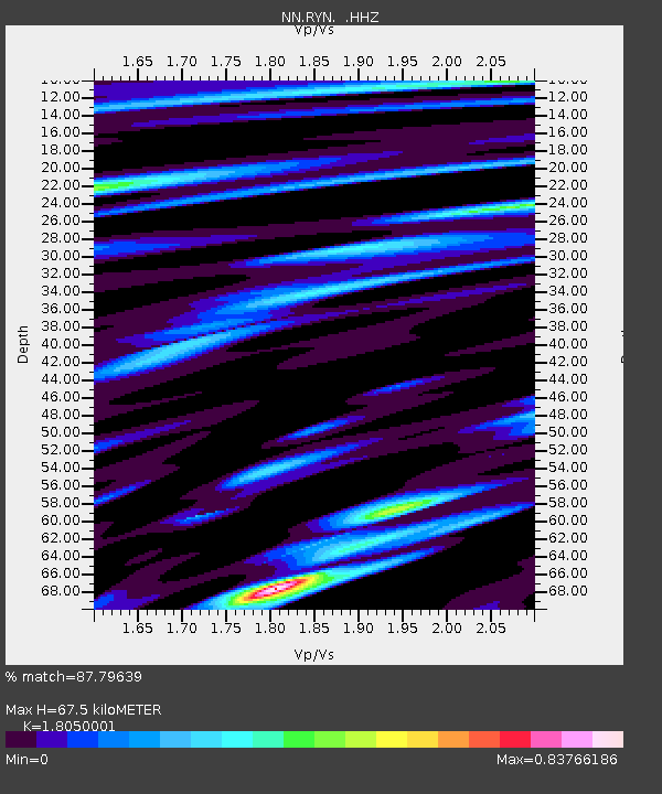
| Estimated Moho Depth: |
67.5 km |
| Estimated Crust Vp/Vs: |
1.81 |
| Assumed Crust Vp: |
6.279 km/s |
| Estimated Crust Vs: |
3.478 km/s |
| Estimated Crust Poisson's Ratio: |
0.28 |
|
| Radial Match: |
87.79639 % |
| Radial Bump: |
398 |
| Transverse Match: |
85.72897 % |
| Transverse Bump: |
400 |
| SOD ConfigId: |
512894 |
| Insert Time: |
2013-09-14 00:41:20.237 +0000 |
| GWidth: |
2.5 |
| Max Bumps: |
400 |
| Tol: |
0.001 |
|

Signal To Noise
| Channel | StoN | STA | LTA |
| NN:RYN: :HHZ:20130511T20:57:57.264988Z | 19.022377 | 9.009796E-7 | 4.73642E-8 |
| NN:RYN: :HHN:20130511T20:57:57.264988Z | 4.477578 | 2.0906006E-7 | 4.669043E-8 |
| NN:RYN: :HHE:20130511T20:57:57.264988Z | 4.342303 | 2.0647633E-7 | 4.7549957E-8 |
| Arrivals |
| Ps | 8.9 SECOND |
| PpPs | 29 SECOND |
| PsPs/PpSs | 38 SECOND |


