You are here: Home > Network List > TA - USArray Transportable Network (new EarthScope stations) Stations List
> Station G03D McMinnville, OR, USA > Earthquake Result Viewer
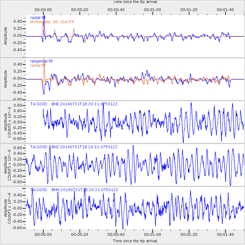
G03D McMinnville, OR, USA - Earthquake Result Viewer
*The percent match for this event was below the threshold and hence no stack was calculated.
| Earthquake location: |
Southern Peru |
| Earthquake latitude/longitude: |
-16.5/-71.2 |
| Earthquake time(UTC): |
2014/07/31 (212) 18:09:19 GMT |
| Earthquake Depth: |
116 km |
| Earthquake Magnitude: |
4.9 MW, 3.6 ms1mx, 3.8 Ms1, 3.8 MS, 5.0 mbtmp, 4.6 mb1mx, 4.7 mb1, 4.6 mb |
| Earthquake Catalog/Contributor: |
ISC/ISC |
|
| Network: |
TA USArray Transportable Network (new EarthScope stations) |
| Station: |
G03D McMinnville, OR, USA |
| Lat/Lon: |
45.21 N/123.26 W |
| Elevation: |
222 m |
|
| Distance: |
77.4 deg |
| Az: |
325.17 deg |
| Baz: |
129.168 deg |
| Ray Param: |
$rayparam |
*The percent match for this event was below the threshold and hence was not used in the summary stack. |
|
| Radial Match: |
55.108658 % |
| Radial Bump: |
400 |
| Transverse Match: |
55.860493 % |
| Transverse Bump: |
400 |
| SOD ConfigId: |
3390531 |
| Insert Time: |
2019-04-13 03:06:49.971 +0000 |
| GWidth: |
2.5 |
| Max Bumps: |
400 |
| Tol: |
0.001 |
|
Signal To Noise
| Channel | StoN | STA | LTA |
| TA:G03D: :BHZ:20140731T18:20:31.075012Z | 1.3863516 | 3.4893137E-7 | 2.516904E-7 |
| TA:G03D: :BHN:20140731T18:20:31.075012Z | 0.51723075 | 1.5838735E-7 | 3.0622184E-7 |
| TA:G03D: :BHE:20140731T18:20:31.075012Z | 2.033544 | 3.6431118E-7 | 1.7915085E-7 |
| Arrivals |
| Ps | |
| PpPs | |
| PsPs/PpSs | |


