You are here: Home > Network List > TA - USArray Transportable Network (new EarthScope stations) Stations List
> Station G59A Clarenceville, QC, USA > Earthquake Result Viewer
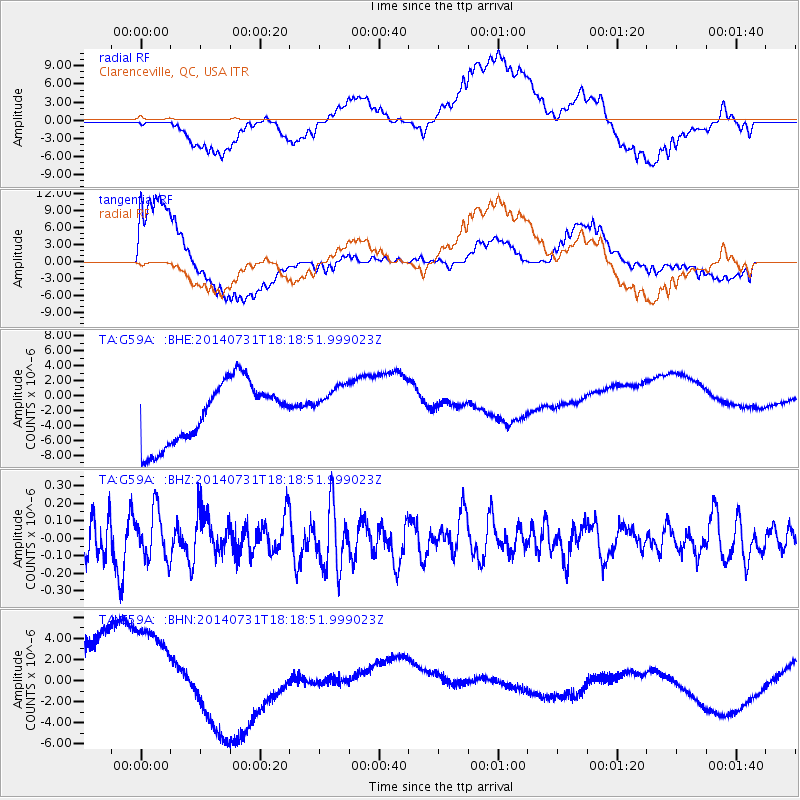
G59A Clarenceville, QC, USA - Earthquake Result Viewer
*The percent match for this event was below the threshold and hence no stack was calculated.
| Earthquake location: |
Southern Peru |
| Earthquake latitude/longitude: |
-16.5/-71.2 |
| Earthquake time(UTC): |
2014/07/31 (212) 18:09:19 GMT |
| Earthquake Depth: |
116 km |
| Earthquake Magnitude: |
4.9 MW, 3.6 ms1mx, 3.8 Ms1, 3.8 MS, 5.0 mbtmp, 4.6 mb1mx, 4.7 mb1, 4.6 mb |
| Earthquake Catalog/Contributor: |
ISC/ISC |
|
| Network: |
TA USArray Transportable Network (new EarthScope stations) |
| Station: |
G59A Clarenceville, QC, USA |
| Lat/Lon: |
45.08 N/73.18 W |
| Elevation: |
36 m |
|
| Distance: |
61.3 deg |
| Az: |
358.41 deg |
| Baz: |
177.846 deg |
| Ray Param: |
$rayparam |
*The percent match for this event was below the threshold and hence was not used in the summary stack. |
|
| Radial Match: |
20.25973 % |
| Radial Bump: |
400 |
| Transverse Match: |
43.347446 % |
| Transverse Bump: |
400 |
| SOD ConfigId: |
3390531 |
| Insert Time: |
2019-04-13 03:06:52.321 +0000 |
| GWidth: |
2.5 |
| Max Bumps: |
400 |
| Tol: |
0.001 |
|
Signal To Noise
| Channel | StoN | STA | LTA |
| TA:G59A: :BHZ:20140731T18:18:51.999023Z | 0.9608856 | 1.4107673E-7 | 1.4681947E-7 |
| TA:G59A: :BHN:20140731T18:18:51.999023Z | 1.0588375 | 7.660129E-6 | 7.2344715E-6 |
| TA:G59A: :BHE:20140731T18:18:51.999023Z | 0.70133364 | 2.8276047E-6 | 4.031754E-6 |
| Arrivals |
| Ps | |
| PpPs | |
| PsPs/PpSs | |


