You are here: Home > Network List > PS - Pacific21 Stations List
> Station PSI Parapat, Indonesia > Earthquake Result Viewer
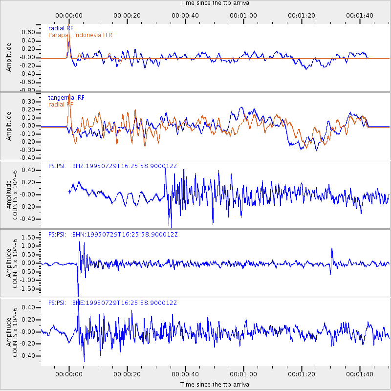
PSI Parapat, Indonesia - Earthquake Result Viewer
*The percent match for this event was below the threshold and hence no stack was calculated.
| Earthquake location: |
Southeast Of Honshu, Japan |
| Earthquake latitude/longitude: |
30.4/138.3 |
| Earthquake time(UTC): |
1995/07/29 (210) 16:18:44 GMT |
| Earthquake Depth: |
436 km |
| Earthquake Magnitude: |
5.5 MB, 5.6 UNKNOWN |
| Earthquake Catalog/Contributor: |
WHDF/NEIC |
|
| Network: |
PS Pacific21 |
| Station: |
PSI Parapat, Indonesia |
| Lat/Lon: |
2.69 N/98.92 E |
| Elevation: |
987 m |
|
| Distance: |
46.3 deg |
| Az: |
241.218 deg |
| Baz: |
49.319 deg |
| Ray Param: |
$rayparam |
*The percent match for this event was below the threshold and hence was not used in the summary stack. |
|
| Radial Match: |
65.3164 % |
| Radial Bump: |
400 |
| Transverse Match: |
50.253967 % |
| Transverse Bump: |
400 |
| SOD ConfigId: |
4480 |
| Insert Time: |
2010-02-27 03:27:52.855 +0000 |
| GWidth: |
2.5 |
| Max Bumps: |
400 |
| Tol: |
0.001 |
|
Signal To Noise
| Channel | StoN | STA | LTA |
| PS:PSI: :BHN:19950729T16:25:58.900012Z | 8.142639 | 5.031306E-7 | 6.178962E-8 |
| PS:PSI: :BHE:19950729T16:25:58.900012Z | 1.9732124 | 1.5118935E-7 | 7.662092E-8 |
| PS:PSI: :BHZ:19950729T16:25:58.900012Z | 1.7076918 | 1.5413895E-7 | 9.0261565E-8 |
| Arrivals |
| Ps | |
| PpPs | |
| PsPs/PpSs | |


