You are here: Home > Network List > US - United States National Seismic Network Stations List
> Station AGMN Agassiz National Wildlife Refuge, Minnesota, USA > Earthquake Result Viewer
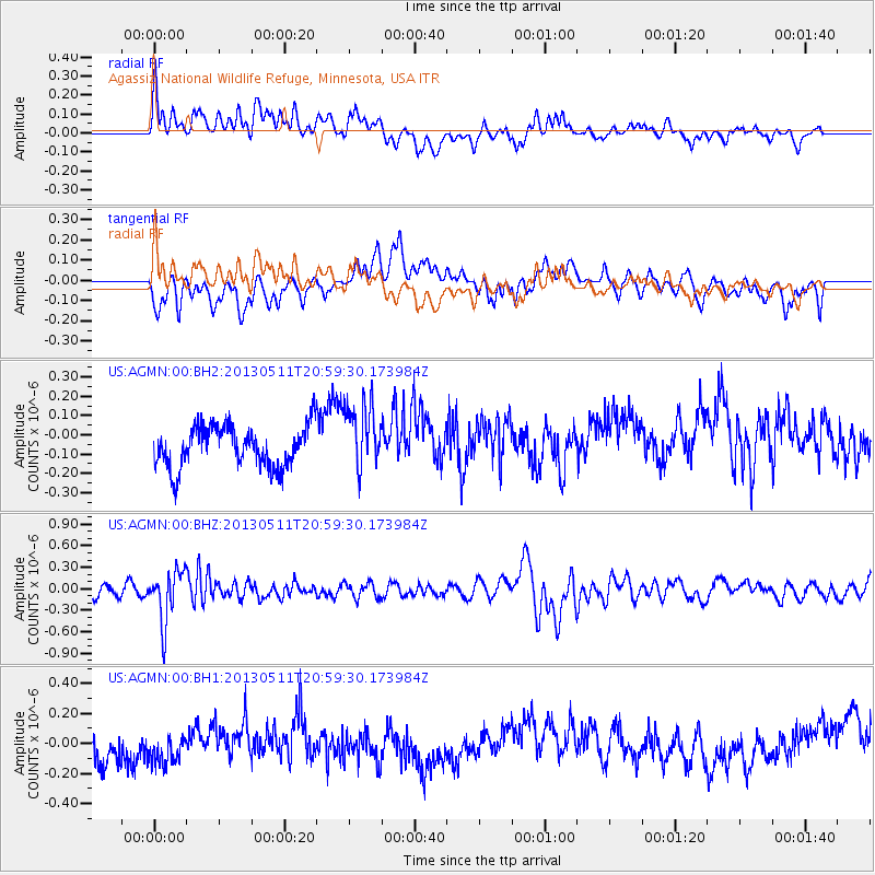
AGMN Agassiz National Wildlife Refuge, Minnesota, USA - Earthquake Result Viewer
*The percent match for this event was below the threshold and hence no stack was calculated.
| Earthquake location: |
Tonga Islands |
| Earthquake latitude/longitude: |
-18.0/-175.1 |
| Earthquake time(UTC): |
2013/05/11 (131) 20:46:57 GMT |
| Earthquake Depth: |
213 km |
| Earthquake Magnitude: |
5.8 MB, 6.4 MW, 6.4 MW |
| Earthquake Catalog/Contributor: |
WHDF/NEIC |
|
| Network: |
US United States National Seismic Network |
| Station: |
AGMN Agassiz National Wildlife Refuge, Minnesota, USA |
| Lat/Lon: |
48.30 N/95.86 W |
| Elevation: |
351 m |
|
| Distance: |
96.3 deg |
| Az: |
41.299 deg |
| Baz: |
250.186 deg |
| Ray Param: |
$rayparam |
*The percent match for this event was below the threshold and hence was not used in the summary stack. |
|
| Radial Match: |
46.985943 % |
| Radial Bump: |
400 |
| Transverse Match: |
52.1556 % |
| Transverse Bump: |
400 |
| SOD ConfigId: |
512894 |
| Insert Time: |
2013-09-14 00:45:54.527 +0000 |
| GWidth: |
2.5 |
| Max Bumps: |
400 |
| Tol: |
0.001 |
|
Signal To Noise
| Channel | StoN | STA | LTA |
| US:AGMN:00:BHZ:20130511T20:59:30.173984Z | 4.904153 | 3.5728252E-7 | 7.2853055E-8 |
| US:AGMN:00:BH1:20130511T20:59:30.173984Z | 1.046498 | 1.2019173E-7 | 1.14851375E-7 |
| US:AGMN:00:BH2:20130511T20:59:30.173984Z | 1.6656173 | 1.7647984E-7 | 1.0595461E-7 |
| Arrivals |
| Ps | |
| PpPs | |
| PsPs/PpSs | |


