You are here: Home > Network List > UU - University of Utah Regional Network Stations List
> Station TCU Toone Canyon, UT, USA > Earthquake Result Viewer
TCU Toone Canyon, UT, USA - Earthquake Result Viewer
| Earthquake location: |
Tonga Islands |
| Earthquake latitude/longitude: |
-18.0/-175.1 |
| Earthquake time(UTC): |
2013/05/11 (131) 20:46:57 GMT |
| Earthquake Depth: |
213 km |
| Earthquake Magnitude: |
5.8 MB, 6.4 MW, 6.4 MW |
| Earthquake Catalog/Contributor: |
WHDF/NEIC |
|
| Network: |
UU University of Utah Regional Network |
| Station: |
TCU Toone Canyon, UT, USA |
| Lat/Lon: |
41.12 N/111.41 W |
| Elevation: |
2269 m |
|
| Distance: |
83.2 deg |
| Az: |
43.007 deg |
| Baz: |
239.238 deg |
| Ray Param: |
0.045809314 |
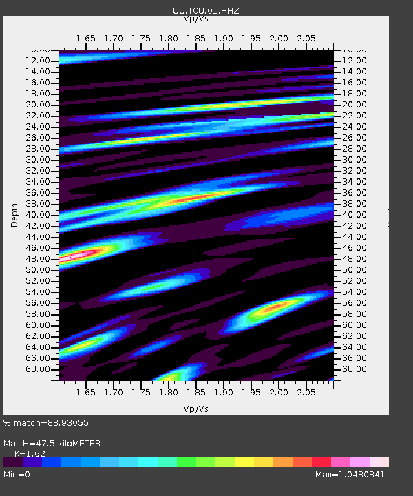
| Estimated Moho Depth: |
47.5 km |
| Estimated Crust Vp/Vs: |
1.62 |
| Assumed Crust Vp: |
6.155 km/s |
| Estimated Crust Vs: |
3.799 km/s |
| Estimated Crust Poisson's Ratio: |
0.19 |
|
| Radial Match: |
88.93055 % |
| Radial Bump: |
400 |
| Transverse Match: |
86.386765 % |
| Transverse Bump: |
400 |
| SOD ConfigId: |
512894 |
| Insert Time: |
2013-09-14 00:49:07.688 +0000 |
| GWidth: |
2.5 |
| Max Bumps: |
400 |
| Tol: |
0.001 |
|

Signal To Noise
| Channel | StoN | STA | LTA |
| UU:TCU:01:HHZ:20130511T20:58:28.798984Z | 11.257817 | 5.771638E-8 | 5.1267826E-9 |
| UU:TCU:01:HHN:20130511T20:58:28.798984Z | 1.0721182 | 6.850575E-9 | 6.389758E-9 |
| UU:TCU:01:HHE:20130511T20:58:28.798984Z | 2.0310614 | 1.3985448E-8 | 6.885783E-9 |
| Arrivals |
| Ps | 4.9 SECOND |
| PpPs | 20 SECOND |
| PsPs/PpSs | 25 SECOND |


