You are here: Home > Network List > UW - Pacific Northwest Regional Seismic Network Stations List
> Station LEBA Lebam, WA, USA > Earthquake Result Viewer
LEBA Lebam, WA, USA - Earthquake Result Viewer
| Earthquake location: |
Tonga Islands |
| Earthquake latitude/longitude: |
-18.0/-175.1 |
| Earthquake time(UTC): |
2013/05/11 (131) 20:46:57 GMT |
| Earthquake Depth: |
213 km |
| Earthquake Magnitude: |
5.8 MB, 6.4 MW, 6.4 MW |
| Earthquake Catalog/Contributor: |
WHDF/NEIC |
|
| Network: |
UW Pacific Northwest Regional Seismic Network |
| Station: |
LEBA Lebam, WA, USA |
| Lat/Lon: |
46.55 N/123.56 W |
| Elevation: |
73 m |
|
| Distance: |
79.2 deg |
| Az: |
33.378 deg |
| Baz: |
229.352 deg |
| Ray Param: |
0.04855856 |
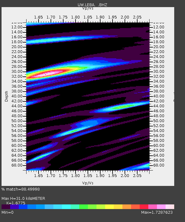
| Estimated Moho Depth: |
31.0 km |
| Estimated Crust Vp/Vs: |
1.68 |
| Assumed Crust Vp: |
6.566 km/s |
| Estimated Crust Vs: |
3.914 km/s |
| Estimated Crust Poisson's Ratio: |
0.22 |
|
| Radial Match: |
88.49998 % |
| Radial Bump: |
400 |
| Transverse Match: |
77.05176 % |
| Transverse Bump: |
400 |
| SOD ConfigId: |
512894 |
| Insert Time: |
2013-09-14 00:49:40.051 +0000 |
| GWidth: |
2.5 |
| Max Bumps: |
400 |
| Tol: |
0.001 |
|
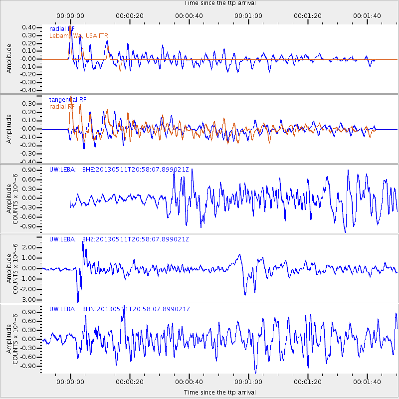
Signal To Noise
| Channel | StoN | STA | LTA |
| UW:LEBA: :BHZ:20130511T20:58:07.899021Z | 14.953943 | 1.2301425E-6 | 8.226208E-8 |
| UW:LEBA: :BHN:20130511T20:58:07.899021Z | 1.9496524 | 2.732753E-7 | 1.4016618E-7 |
| UW:LEBA: :BHE:20130511T20:58:07.899021Z | 2.772748 | 2.9422378E-7 | 1.0611271E-7 |
| Arrivals |
| Ps | 3.3 SECOND |
| PpPs | 12 SECOND |
| PsPs/PpSs | 16 SECOND |


