You are here: Home > Network List > CN - Canadian National Seismograph Network Stations List
> Station KAPO KAPUSKASING, ON > Earthquake Result Viewer
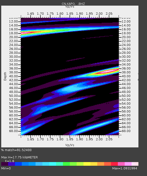
KAPO KAPUSKASING, ON - Earthquake Result Viewer
| Earthquake location: |
Near Coast Of Guatemala |
| Earthquake latitude/longitude: |
13.5/-91.4 |
| Earthquake time(UTC): |
2013/05/12 (132) 07:29:59 GMT |
| Earthquake Depth: |
11 km |
| Earthquake Magnitude: |
5.5 MS, 5.2 MB, 5.8 MW, 5.6 MW |
| Earthquake Catalog/Contributor: |
WHDF/NEIC |
|
| Network: |
CN Canadian National Seismograph Network |
| Station: |
KAPO KAPUSKASING, ON |
| Lat/Lon: |
49.45 N/82.51 W |
| Elevation: |
210 m |
|
| Distance: |
36.6 deg |
| Az: |
9.713 deg |
| Baz: |
194.566 deg |
| Ray Param: |
0.07658627 |
| Estimated Moho Depth: |
17.75 km |
| Estimated Crust Vp/Vs: |
1.60 |
| Assumed Crust Vp: |
6.467 km/s |
| Estimated Crust Vs: |
4.042 km/s |
| Estimated Crust Poisson's Ratio: |
0.18 |
|
| Radial Match: |
91.52488 % |
| Radial Bump: |
398 |
| Transverse Match: |
46.45839 % |
| Transverse Bump: |
400 |
| SOD ConfigId: |
512894 |
| Insert Time: |
2013-09-14 01:13:05.467 +0000 |
| GWidth: |
2.5 |
| Max Bumps: |
400 |
| Tol: |
0.001 |
|

Signal To Noise
| Channel | StoN | STA | LTA |
| CN:KAPO: :BHZ:20130512T07:36:34.725004Z | 7.06685 | 5.5345964E-7 | 7.831773E-8 |
| CN:KAPO: :BHN:20130512T07:36:34.725004Z | 2.936598 | 3.0074884E-7 | 1.0241403E-7 |
| CN:KAPO: :BHE:20130512T07:36:34.725004Z | 3.5165212 | 1.8845546E-7 | 5.3591446E-8 |
| Arrivals |
| Ps | 1.8 SECOND |
| PpPs | 6.6 SECOND |
| PsPs/PpSs | 8.4 SECOND |


