You are here: Home > Network List > NN - Western Great Basin/Eastern Sierra Nevada Stations List
> Station RUB Rubicon Trail, California w84 > Earthquake Result Viewer
RUB Rubicon Trail, California w84 - Earthquake Result Viewer
| Earthquake location: |
Near Coast Of Guatemala |
| Earthquake latitude/longitude: |
13.5/-91.4 |
| Earthquake time(UTC): |
2013/05/12 (132) 07:29:59 GMT |
| Earthquake Depth: |
11 km |
| Earthquake Magnitude: |
5.5 MS, 5.2 MB, 5.8 MW, 5.6 MW |
| Earthquake Catalog/Contributor: |
WHDF/NEIC |
|
| Network: |
NN Western Great Basin/Eastern Sierra Nevada |
| Station: |
RUB Rubicon Trail, California w84 |
| Lat/Lon: |
39.05 N/120.15 W |
| Elevation: |
2045 m |
|
| Distance: |
36.0 deg |
| Az: |
320.353 deg |
| Baz: |
127.139 deg |
| Ray Param: |
0.07692736 |
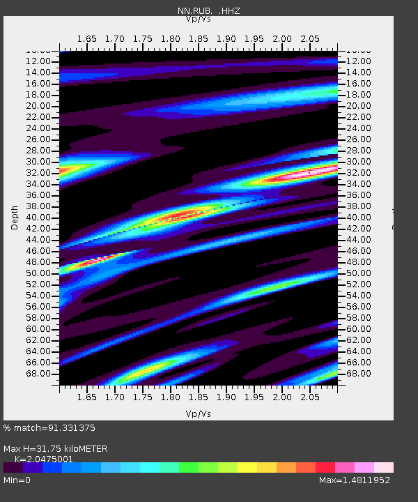
| Estimated Moho Depth: |
31.75 km |
| Estimated Crust Vp/Vs: |
2.05 |
| Assumed Crust Vp: |
6.597 km/s |
| Estimated Crust Vs: |
3.222 km/s |
| Estimated Crust Poisson's Ratio: |
0.34 |
|
| Radial Match: |
91.331375 % |
| Radial Bump: |
377 |
| Transverse Match: |
67.664856 % |
| Transverse Bump: |
400 |
| SOD ConfigId: |
512894 |
| Insert Time: |
2013-09-14 01:20:55.352 +0000 |
| GWidth: |
2.5 |
| Max Bumps: |
400 |
| Tol: |
0.001 |
|

Signal To Noise
| Channel | StoN | STA | LTA |
| NN:RUB: :HHZ:20130512T07:36:29.385007Z | 5.6710854 | 4.5341818E-7 | 7.995263E-8 |
| NN:RUB: :HHN:20130512T07:36:29.385007Z | 2.1442888 | 1.954963E-7 | 9.11707E-8 |
| NN:RUB: :HHE:20130512T07:36:29.385007Z | 2.3033245 | 2.48686E-7 | 1.0796829E-7 |
| Arrivals |
| Ps | 5.4 SECOND |
| PpPs | 14 SECOND |
| PsPs/PpSs | 19 SECOND |


