You are here: Home > Network List > TA - USArray Transportable Network (new EarthScope stations) Stations List
> Station H46A Fife Lake, MI, USA > Earthquake Result Viewer
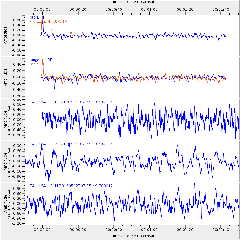
H46A Fife Lake, MI, USA - Earthquake Result Viewer
*The percent match for this event was below the threshold and hence no stack was calculated.
| Earthquake location: |
Near Coast Of Guatemala |
| Earthquake latitude/longitude: |
13.5/-91.4 |
| Earthquake time(UTC): |
2013/05/12 (132) 07:29:59 GMT |
| Earthquake Depth: |
11 km |
| Earthquake Magnitude: |
5.5 MS, 5.2 MB, 5.8 MW, 5.6 MW |
| Earthquake Catalog/Contributor: |
WHDF/NEIC |
|
| Network: |
TA USArray Transportable Network (new EarthScope stations) |
| Station: |
H46A Fife Lake, MI, USA |
| Lat/Lon: |
44.54 N/85.20 W |
| Elevation: |
329 m |
|
| Distance: |
31.4 deg |
| Az: |
8.486 deg |
| Baz: |
191.58 deg |
| Ray Param: |
$rayparam |
*The percent match for this event was below the threshold and hence was not used in the summary stack. |
|
| Radial Match: |
58.297817 % |
| Radial Bump: |
400 |
| Transverse Match: |
52.811577 % |
| Transverse Bump: |
400 |
| SOD ConfigId: |
512894 |
| Insert Time: |
2013-09-14 01:26:45.242 +0000 |
| GWidth: |
2.5 |
| Max Bumps: |
400 |
| Tol: |
0.001 |
|
Signal To Noise
| Channel | StoN | STA | LTA |
| TA:H46A: :BHZ:20130512T07:35:49.70001Z | 2.8762178 | 6.77779E-7 | 2.356494E-7 |
| TA:H46A: :BHN:20130512T07:35:49.70001Z | 1.796902 | 3.9316916E-7 | 2.188039E-7 |
| TA:H46A: :BHE:20130512T07:35:49.70001Z | 0.6908917 | 1.5271948E-7 | 2.2104693E-7 |
| Arrivals |
| Ps | |
| PpPs | |
| PsPs/PpSs | |


