You are here: Home > Network List > TA - USArray Transportable Network (new EarthScope stations) Stations List
> Station I46A Reed City, MI, USA > Earthquake Result Viewer
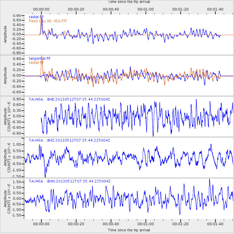
I46A Reed City, MI, USA - Earthquake Result Viewer
*The percent match for this event was below the threshold and hence no stack was calculated.
| Earthquake location: |
Near Coast Of Guatemala |
| Earthquake latitude/longitude: |
13.5/-91.4 |
| Earthquake time(UTC): |
2013/05/12 (132) 07:29:59 GMT |
| Earthquake Depth: |
11 km |
| Earthquake Magnitude: |
5.5 MS, 5.2 MB, 5.8 MW, 5.6 MW |
| Earthquake Catalog/Contributor: |
WHDF/NEIC |
|
| Network: |
TA USArray Transportable Network (new EarthScope stations) |
| Station: |
I46A Reed City, MI, USA |
| Lat/Lon: |
43.94 N/85.45 W |
| Elevation: |
359 m |
|
| Distance: |
30.8 deg |
| Az: |
8.383 deg |
| Baz: |
191.323 deg |
| Ray Param: |
$rayparam |
*The percent match for this event was below the threshold and hence was not used in the summary stack. |
|
| Radial Match: |
63.749424 % |
| Radial Bump: |
400 |
| Transverse Match: |
43.665943 % |
| Transverse Bump: |
400 |
| SOD ConfigId: |
512894 |
| Insert Time: |
2013-09-14 01:27:08.276 +0000 |
| GWidth: |
2.5 |
| Max Bumps: |
400 |
| Tol: |
0.001 |
|
Signal To Noise
| Channel | StoN | STA | LTA |
| TA:I46A: :BHZ:20130512T07:35:44.225004Z | 3.1676083 | 6.642035E-7 | 2.0968615E-7 |
| TA:I46A: :BHN:20130512T07:35:44.225004Z | 1.6485338 | 7.1679204E-7 | 4.3480577E-7 |
| TA:I46A: :BHE:20130512T07:35:44.225004Z | 1.1164383 | 3.8086822E-7 | 3.4114578E-7 |
| Arrivals |
| Ps | |
| PpPs | |
| PsPs/PpSs | |


